DANCING RIDGE FIRE TOWER (LY2684)
DANCING RIDGE FIRE TOWER
Spatial/elevation data
| Coordinates | N 41.1635° W 75.170016° |
| Elevation | Unknown |
| Location | Pennsylvania
Monroe County Skytop Quad |
Mark description
| Type | Landmark/Intersection Station |
| Setting | Fire Lookout Tower |
| Monumented | 1940 by NGS |
| Description (NGS) | NGS Datasheet |
NGS recovery information
Descriptive text
Recovered in destroyed condition.Narrative and photographs
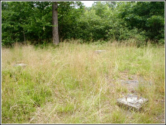
We took a little detour on the way home from a geocache hunt in the area to search for what might remain of this tower. Unfortunately, we did not find the tower standing. Only the concrete footings, and a platform that may have been at the base of the stairs, still exist. The tower itself was likely dismantled and removed completely from the site. This landmark station certainly had a colorful name. As we hiked to the coordinates, I envisioned native Anericans in ceremonial dress dancing on this knoll at night to tribal music that could be heard from afar.
Photographs and a report on the condition of this station were submitted to NGS, which subsequently marked this station officially Destroyed.


Station landmark no longer exists.
This third order horizontal control station was located and identified but the station landmark itself was destroyed. The entire fire tower appears to have been dismantled and removed. Only the four concrete footings for the legs of the structure remain. At what would have been the center of the base of the lookout tower, a Garmin GPSmap76 receiver was used to record WAAS-corrected coordinates which were identical to the adjusted coordinates listed on the NGS datasheet.
~Rich in NEPA~
Note: An official recovery report will be submitted to NGS along with photos of the available evidence.


