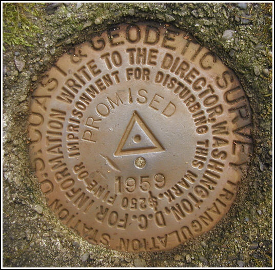
PROMISED (LY1163)
PROMISED
Spatial/elevation data
| Coordinates | N 41.32465° W 75.19605° |
| Elevation | 1870.13 ft. |
| Location | Pennsylvania
Pike County Promised Land Quad |
Mark description
| Type | Triangulation Station Disk |
| Setting | Square Concrete Monument |
| Monumented | 1959 by NGS |
| Description (NGS) | NGS Datasheet |
NGS recovery information
Descriptive text
The station mark and reference marks 1 and 2 were recovered in good condition. RM 1 is approximately 13.8 feet south of Rock Oak Trail, and RM 2 is approximately 11 feet south of the trail. The metal witness post still exists, but there is no sign. The blazed trees were not found.Narrative and photographs
A quick walk on the Rock Oak Trail, after finding LY1165 near the parking area, brought us to the PROMISED marks. The station mark was easy to spot as it was well exposed and marked by a metal witness post (though the post held no sign). Reference mark 2 was also obvious because it sits in the open and is set in a monument projecting about an inch. Reference mark 1 required more thorough searching, and we eventually resorted to measuring from the station mark using the distance and bearing values from the datasheet box score. Working with the measuring tape in the thick rhododendron took some time, but as always it put us right on top of the mark. We noted some discrepancies in the distances from the centerline of the trail to the reference marks; likely this is due to the trail having slightly changed its course over time. All three marks are in beautiful condition with legible stamping.


Station recovered in good condition.
This first order triangulation station is situated along Rock Oak Trail within Promised Land State Park. The 1959 “to reach” directions are still reliable. The triangle-blazed oak tree no longer exist, but the witness post remains (no signage). A handheld GPS receiver was helpful in pinpointing the location of the station.
The station and its two reference marks were found to be pretty much as described except RM1 is 13.8 feet south of the trail, and RM2 is 11 feet south of the trail. There are no blazed trees near either of the reference marks.
At the station a Garmin GPSmap76 receiver with active remote antenna was used to record WAAS-corrected coordinates which were identical (within 0.001 minute) to the adjusted coordinates listed in the NGS datasheet. All marks are now well exposed, in good condition, and the stamped designations are legible. ~Rich in NEPA~


| Designation | Status | Condition | Image |
|---|---|---|---|
| PROMISED RM 1 | Recovered | Good |
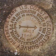
|
| PROMISED RM 2 | Recovered | Good |
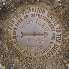
|