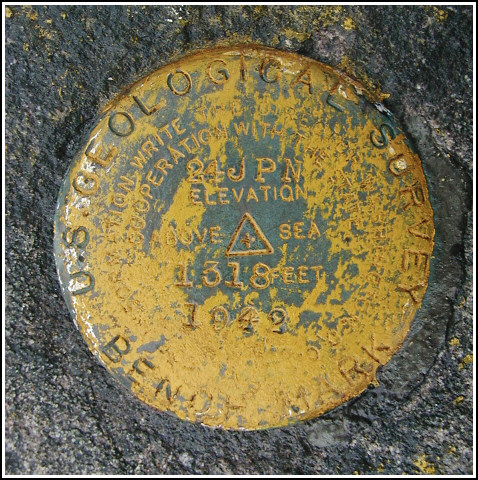
24 JPN
24 JPN
Recovered in Good Condition on December 24, 2003
Spatial/elevation data
| Coordinates | N 41.398367° W 75.626833° |
| Elevation | 1318.169 ft. |
| Location | Pennsylvania
Lackawanna County Scranton Quad |
Mark description
| Type | Bench Mark Disk |
| Setting | Rock Outcrop |
| Monumented | 1942 by USGS |
| Description (USGS) | Scranton; about 1.0 mi SE. of E. & W. V. RR. overhead bridge over State Highway 307; 420 ft W. of intersection of hwy. and rd. to Scranton Spring Brook Water Co. reservoir; 40 ft NE. of rd.; in top of large rock outcrop about 4 ft higher than level of rd.; standard tablet stamped “24 JPN 1942 1318”. Elev. 1318.169 ft. Reference mark; 18 ft W. of tablet; 30 ft NE. of rd.; about 4 ft higher than level of rd.; on top of outcrop; chiseled square. Elev. 1317.87 ft. |
USGS recovery information
View reportNarrative and photographs
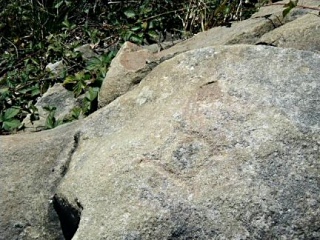
Earlier this week, I’d been on my way home from a walk at Lake Scranton when I happened to notice some yellow paint on a rock outcrop just off the highway. I checked my USGS sheets and maps to see if there might possibly be a benchmark disk in the general area, and I was pleased to see that there was a mark that appeared to match. On this ugly, rainy Christmas Eve morning I took the quick drive up Route 307 to check out the painted rock outcrop. I parked in an empty lot belonging to a garden apartment complex and walked for only a few hundred feet through the woods until I emerged on the rock outcrop-and the mark was at my feet.


| Designation | Status | Condition | Image |
|---|---|---|---|
| 24 JPN RM | Recovered | Good |
|