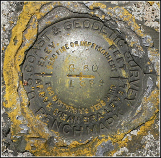
G 60 (LY1043)
G 60
Spatial/elevation data
| Coordinates | N 41.67856° W 75.473116° |
| Elevation | 1561.55 ft. |
| Location | Pennsylvania
Susquehanna County Forest City Quad |
Mark description
| Type | Bench Mark Disk |
| Setting | Bridge Abutment |
| Monumented | 1934 by NGS |
| Description (NGS) | NGS Datasheet |
NGS recovery information
Descriptive text
Recovered in good condition. The railbed is now the D and H Rail-Trail, maintained by the Rail-Trail Council of Northeastern Pennsylvania. It is open to public access by foot and non-motorized vehicles. Handheld GPS coordinates for the station are 41 40 42.8(N) 075 28 23.2(W).Narrative and photographs
For the first time all year, this weekend decent weather and days off coincided. Rich and I decided to take full advantage of this extraordinary event by spending most of Friday and Saturday outdoors. Today, Saturday, had already been chosen for a local ride, to be followed by a simple lunch and then my mother’s choral concert in the evening. Having heard that a significant length (up to ten miles) of the nearby D & H Rail-Trail had been improved for walking and riding, we decided it was worth exploring.
We parked near the tank in Simpson and began pedaling northeast along the O & W Rail-Trail. After a bit more than a mile, we hopped down to the D & H via a very short connector trail and continued heading north, passing fishermen and the occasional fellow biker, as well as old stone abutments and other evidence of the long-departed railroad. We passed the site of the old Forest City Railroad Station, now commemorated by a brightly painted sign, and traveled another mile or so of pretty but unremarkable trail before Rich wanted to stop for a short break. I continued on ahead, and when he caught up to me I started to tell him about the gaging station I could see across the river. He stopped me and said “Didn’t you notice the benchmark on the bridge?!” Obviously, I hadn’t. We continued on to Union Dale, then turned around and stopped to document the benchmark on our return trip.
The disk is in good condition, on the northwest end of the north abutment as described. Some yellow paint still clings to the concrete around the mark, making it easily visible. I had very little trouble reaching the mark, simply by climbing through the bridge railing and right out onto the top of the abutment. From here I could also see two numbers on the bridge, at least one of which matches the bridge number given in the benchmark description, as we discovered later.


