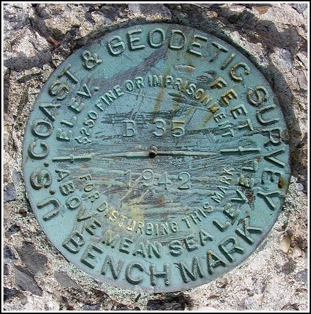
B 35 (LY0791)
B 35
Spatial/elevation data
| Coordinates | N 41.21555° W 74.82055° |
| Elevation | 546.01 ft. |
| Location | New Jersey
Middlesex County South Amboy Quad |
Mark description
| Type | Bench Mark Disk |
| Setting | Concrete Post |
| Monumented | 1942 by NGS |
| Description (NGS) | NGS Datasheet |
Narrative and photographs
While cruising around in the area after an extremely pleasant day of mountain biking at Blue Mountain Lake, Rich asked “Do you want to find a benchmark?” Of course I did, so he parked at the school and checked to see if he still had the coordinates in his GPSr. He didn’t, so he then checked his binder full of printouts to see if he had the datasheet. I didn’t find out if he had it, because I located the mark just a few seconds after getting out of the car. It’s on a crumbling monument about one meter from a utility pole in the front yard of the Sandyston Walpack School. The mark is in very good condition and the designation is legible.


(Recovered on November 15, 2002)
N 41° 12.933’ W 074° 49.235’
On this gorgeous, sunny, mid-Fall morning I was hunting a Geocache in Stokes State Forest. While driving back to Port Jervis I had plenty of time to search for this benchmark, which was located along NJ Rte 560 just east of Layton. I found it easily using the historic description. At the station my Garmin GPSmap76 receiver indicated approximately 310 feet from the posted coordinates. The disc is in excellent condition and the designation is legible. ~Rich in NEPA~


