648 USGS (LY0602)
648 USGS
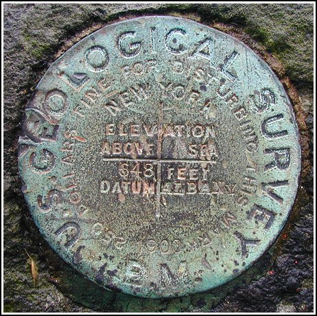
Spatial/elevation data
| Coordinates | N 41.47495° W 74.9156° |
| Elevation | 648.29 ft. |
| Location | Pennsylvania
Pike County Shohola Quad |
Mark description
| Type | Bench Mark Disk |
| Setting | Stone Step |
| Monumented | 1900 by USGS |
| Description (NGS) | NGS Datasheet |
Narrative and photographs
This one was a tough find with the railroad station gone. The posted coordinates were less than 100 feet from what I recorded at the site, but I was initially distracted by a set of steps leading from Route 55 up to Rohman Road. Once I realized that I needed to be up on Rohman Road itself, the situation started to make more sense. It became a matter of finding the correct set of stone steps, which I did a moment later. The mark is now on the second step from the bottom (I suspect that the road was resurfaced and the bottom step was paved over) in the steps just beyond Rohman’s Historic Tavern, which was already quite busy at just 1:00 in the afternoon. The disk is in good condition, especially for being so old. This is another of the turn-of-the-century Albany marks (see also NA1433).

