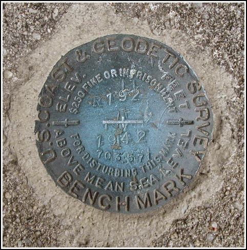
R 192 (KV2822)
R 192
Spatial/elevation data
| Coordinates | N 40.860667° W 75.753733° |
| Elevation | 702.89 ft. |
| Location | Pennsylvania
Carbon County Nesquehoning Quad |
Mark description
| Type | Bench Mark Disk |
| Setting | Concrete Wall |
| Monumented | 1942 by NGS |
| Description (NGS) | NGS Datasheet |
Narrative and photographs
This benchmark disk was found set as described in the top surface of the concrete retaining wall along Mauch Chunk Creek in Jim Thorpe. The station was reached easily via the historic description, though it is located northwest of the centerline of the road—West Broadway—rather than southwest. The disk is in good condition, with the date, designation, and elevation (NGVD 29 datum) clearly legible.


N 40° 51.637’ W 075° 45.226’
Recovered in good condition.
This second order vertical control station is set in top center of a triangular-shaped concrete and stone retaining wall situated between West Broadway and Mauch Chunk Creek, and roughly 3 feet above street level. The historical description leads reliably to the station. The powerpole number referred to is the same, but the town of Mauch Chunk is now called Jim Thorpe. At the station a Garmin GPSmap76 receiver with remote active antenna was used to record WAAS-corrected coordinates which were 40.3 feet from the scaled coordinates listed on the NGS datasheet. ~Rich in NEPA~


