MARY (HW3268)
MARY

Spatial/elevation data
| Coordinates | N 38.650017° W 78.317582° |
| Elevation | 3515 ft. |
| Location | Virginia
Page County Thornton Gap Quad |
Mark description
| Type | Triangulation Station Disk |
| Setting | Boulder |
| Monumented | 1965 by NGS |
| Description (NGS) | NGS Datasheet |
NGS recovery information
Descriptive text
The triangulation station, both reference marks, the azimuth mark, and R 17 were recovered in good condition. Handheld GPS coordinates for RM 1 are 38 39 00.4(N) 078 19 03.1(W). Handheld GPS coordinates for RM 2 are 38 38 59.6(N) 078 19 03.5(W).Narrative and photographs
We began our hike from the Buck Hollow Trail parking area, hiking WNW along the Meadow Spring Trail up to the Appalachian Trail. We finally reached an outcropping, (what we thought was) Mary’s Rock on the Mary’s Rock Trail off the A-T. However, we were very surprised to see that the GPSr was still pointing some 200 feet away! We followed it only to discover that the mark was actually on an impossibly high “finger” of rock sticking up into the wind with hundreds of feet of sheer dropoff below!
We spotted both RMs and were able to climb high enough to see the station disk and R 17, the USGS disk in the same location, but we just couldn’t bring ourselves to climb all the way up with our equipment and stand in that wind. A trio of hardy German hikers lunching atop the rock was all too eager to help us out, and they took a few very nice closeups of the marks for us. We then took photos ourselves of the reference marks; Rich did RM 1 and I did RM 2. These were much less intimidating than the main station.
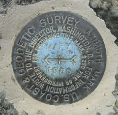
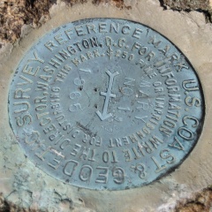
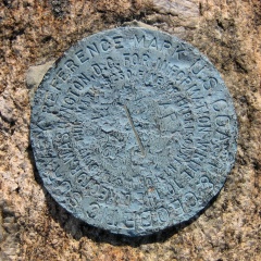
All marks are in reasonably good condition. MARY is worn, scratched and slightly bent but it seems solidly set.


| Designation | Status | Condition | Image |
|---|---|---|---|
| MARY AZ MK | Recovered | Good |
|
| MARY RM 1 | Recovered | Good |
|
| MARY RM 2 | Recovered | Good |
|