ET 29 WCE (HW3288)
ET 29 WCE
Spatial/elevation data
| Coordinates | N 38.756435° W 78.251862° |
| Elevation | 2859 ft. |
| Location | Virginia
Rappahannock County Bentonville Quad |
Mark description
| Type | Bench Mark Disk |
| Setting | Stone Wall |
| Monumented | 1959 by USGS |
| Description (NGS) | NGS Datasheet |
NGS recovery information
Descriptive text
The station and reference mark 2 were not found. Reference mark 1 was found in poor condition, and the azimuth mark was found in good condition. The stone wall into which the station mark was set has been repaired or rebuilt and there is no evidence of the disk. Reference mark 2 was searched for using the description and measurements from the box score, but it could not be found. Reference mark 1 was found on a stone culvert as described. It is secure in its setting but the arrow on the disk, which should be pointing easterly toward the station mark, actually points to the south. This is potentially confusing and may indicate that the culvert was disturbed or rebuilt at some point. The azimuth mark was found in good condition at the Range View overlook, as described. Handheld GPS coordinates for RM 1 are 38 45 23.2(N) 078 15 07.5(W). Handheld GPS coordinates for RM 2 are 38 45 23.5(N) 078 15 07.2(W). Handheld GPS coordinates for the azimuth mark are 38 45 51.6(N) 078 13 38.3(W).Narrative and photographs
It’s the first day of our Shenandoah National Park adventure, and as expected, we had to begin our trip with a trip along Skyline Drive and a few benchmark searches! This tri-station, which we expected to find at the Mt. Marshall Overlook, was quite an unusual start to our trip. As we typically do, we parked and walked straight to the adjusted coordinates for the station mark, which was supposedly set into the stone wall at the overlook. It only took a second to notice that this section of the stone wall has been repaired or rebuilt, and there is no longer any sign of the station disk. Similarly, we had no luck with RM 2.
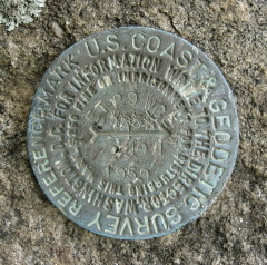
We did locate RM 1 on a stone culvert, as described, but the arrow on the disk was pointing south rather than east toward the station mark. It may have been a simple error when the disk was set, but it may also indicate that the culvert was disturbed or rebuilt at some point.
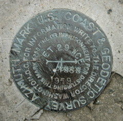
We also found the azimuth mark, in good condition and set as described, at the next overlook toward the northeast (Range View Overlook).
If this experience was any indication of things to come on this trip, I think we’re in for some great views and exciting benchmark hunts!


| Designation | Status | Condition | Image |
|---|---|---|---|
| ET 29 WCE AZ MK | Recovered | Good |
|
| ET 29 WCE RM 1 | Recovered | Poor |
|
| ET 29 WCE RM 2 | Not Found | Unknown (Not Found) |

|