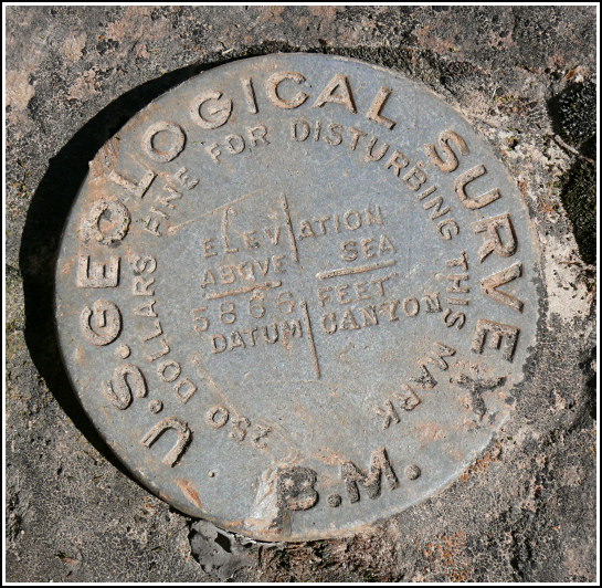
5866 CANYON
5866 CANYON
Recovered in Good Condition on May 14, 2007
Spatial/elevation data
| Coordinates | N 36.05985° W 112.142183° |
| Elevation | 5860.066 ft. |
| Location | Arizona
Coconino County Grand Canyon Quad |
Mark description
| Type | Bench Mark Disk |
| Setting | Boulder |
| Monumented | 1902-1903 by USGS |
| Description (USGS) | Bright Angel Hotel, 0.7 mi. N. of, 15 ft. N. of trail, in large sandstone rock detached from ledge; standard aluminum tablet stamped “5866 CANYON” Revised description (1985): Bright Angel Hotel, about 1.3 mi north of along the Bright Angel Trail, ¼ mile west of a resthouse, at the bottom of a series of short switchbacks, 123 ft east of the last switchback in series, 40 yd east of a deep drain, 32 ft north of and 13 ft lower than trail, set in the top of a large, sloping sandstone boulder, a standard aluminum tablet. |
Narrative and photographs
While on our descent into the canyon along the Bright Angel Trail, I suggested a detour to search for two USGS benchmark disks I had seen on the topo map. They were just a short distance off the trail, but what incredible views these sites offered—probably views seen by very few people, since most people (probably wisely) stick to the trail. We had no problem reaching either of the locations, and never felt in any danger. This disk, the first we found, is undated (but based on the style was likely established between 1900 and 1910) and is in fairly good condition, with some minor damage to one edge that probably doesn’t compromise its position.


