4850 CANYON
4850 CANYON
Recovered in Good Condition on May 14, 2007
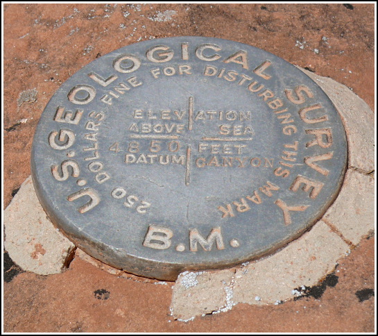
Spatial/elevation data
| Coordinates | N 36.0648° W 112.137833° |
| Elevation | 4843.870 ft. |
| Location | Arizona
Coconino County Grand Canyon Quad |
Mark description
| Type | Bench Mark Disk |
| Setting | Rock Outcrop |
| Monumented | 1902-1903 by USGS |
| Description (USGS) | Bright Angel Hotel, 1.5 mi. N. of, on rim of red wall, 50 ft. NW. of ravine, 25 ft. N. of trail, in brown rock detached from ledge; standard aluminum tablet stamped “4850 CANYON” Revised description (1985): Bright Angel Hotel, about 2.7 mi. north of along the Bright Angel Trail, 250 yd SW of a resthouse, 110 ft north of a switchback near the drain bottom, 90 ft west of drain, 20 ft south of the top of a sheer cliff about 200 ft high, set in the top of a brown boulder projecting about 3 ft, a standard aluminum tablet. |
Narrative and photographs
While on our descent into the canyon along the Bright Angel Trail, I suggested a detour to search for two USGS benchmark disks I had seen on the topo map. They were just a short distance off the trail, but what incredible views these sites offered—probably views seen by very few people, since most people (probably wisely) stick to the trail. We had no problem reaching either of the locations, and never felt in any danger. This was the second of two disks that we found off the trail. This disk is undated (but based on the style was likely established between 1900 and 1910) and is in good condition.


