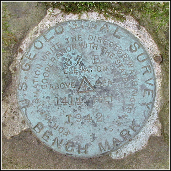
37 B
37 B
Spatial/elevation data
| Coordinates | N 41.44115° W 75.993917° |
| Elevation | 1414.066 ft. |
| Location | Pennsylvania
Wyoming County Center Moreland Quad |
Mark description
| Type | Bench Mark Disk |
| Setting | Boulder |
| Monumented | 1942 by USGS |
| Description (USGS) | Beaumont, 1.2 mi NW. of, along U. S. Highway 309, thence 1.6 mi NE. along dirt rd.; 2.4 mi SW. of Vernon; 80 ft N. and 15 ft W. from junction of rd. SE.; in ledge of rock; standard tablet stamped “37 B 1942 1414”. Elev. 1414.066 ft. |
USGS recovery information
View reportNarrative and photographs
Though we searched around casually for a few other marks today, a PDH mark and 37 B were the only ones we found. We’ve been in this area once before, in the Fall of 2003, to recover EVANS ET and to locate the microwave tower that serves as an azimuth mark for CLIFF ET.
At the time we had no description to work from, but the coordinates Rich pulled off the map were good enough to get us close. They brought us to the intersection of T337, T335 and T322, where we searched for a culvert, boulder, ledge or anywhere else we’d typically expect to find a benchmark. After only five or ten minutes, Rich found the mark on a large boulder in the woods just past the intersection, a few yards west of T322. It appears to be solid in its setting and in good condition overall.
The remainder of the morning was spent driving in the countryside, puzzling over the best way to reach J 58, and sneaking in a few blackberries from the side of the road while taking a quick look for a mark on a culvert. We stopped at Cangiano’s for a roast beef sandwich (for R.) and a “Cousin Vinnie” made with rosemary ham (for Zh). Terrific Summer day!

