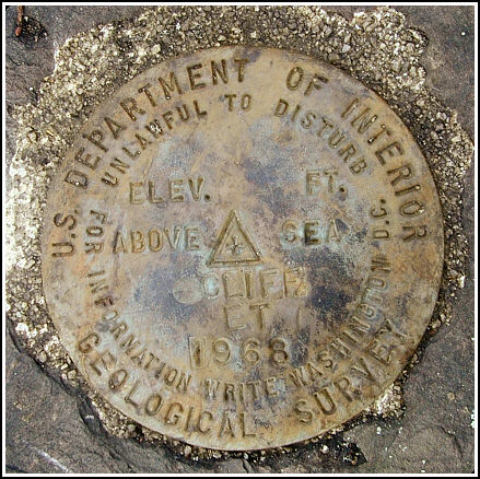
CLIFF ET (LY2801)
CLIFF ET
Spatial/elevation data
| Coordinates | N 41.51185° W 75.988833° |
| Elevation | 820 ft. |
| Location | Pennsylvania
Wyoming County Tunkhannock Quad |
Mark description
| Type | Electronic Traverse Station Disk |
| Setting | Rock Outcrop |
| Monumented | 1968 by USGS |
| Description (NGS) | NGS Datasheet |
NGS recovery information
Descriptive text
The station mark and reference marks 1 and 2 were recovered in good condition. The azimuth mark was viewed from the station. The 30-inch oak tree could not be found.USGS recovery information
View reportNarrative and photographs
Our first attempt to locate this set of marks occurred on Columbus Day. We arrived on the scene eager to search, only to find that the marks could not be reached without crossing private property. Rich knocked on the open farm house door several times and we searched the barn across the street for someone to ask, but that day we had no luck. Aside from many cats wandering the grounds and a cautiously friendly dog who greeted us, the place seemed deserted, as if the human inhabitants had just picked up and left in an instant. (We did wonder why when we drove away, the door that had previously been open was now closed. Perhaps a child was inside who didn’t want to answer the door?)
A bit less than two weeks later, we tried again. This time, the property owner was holding a garage sale—apparently this is a weekly function of his—and he was outside arranging his goods in front of the shed when we arrived. The man was friendly and allowed us immediate access to the area, and wished us well.
We climbed atop the cliff and aside from some necessary “gardening” to remove thorns that were thickly grown, enormous and dangerously sharp, we had no further difficulties. This is a scenic and beautiful spot offering views of nearby farm fields and the mountains surrounding Tunkhannock. All the marks were located with ease using the historic description, and they are all in very good condition.


Recovered in good condition.
This second order triangulation station is situated on a brush-covered hillside near the village of Rosengrant, southwest of Tunkhannock. From Tunkhannock at the intersection of Rt. 6 take Rt. 29 south for roughly 2.3 miles (N41° 30.818’ W075° 58.109’), turn right onto Hickory Road (T377) and bear left immediately at the Y fork for about 0.8 miles to a Y fork (N41° 30.983’ W075° 58.918’), left on Sandbank Road for 0.55 miles to a white farmhouse on the right and a storage shed just beyond. Pack northwest at the shed for roughly 125 yards passing through an opening in a wire fence, along the left edge of a hay field, then on an ATV track leading uphill on the right of an outcropping rock ledge and to the station atop the ledge on the left. A handheld GPS receiver made locating the station an easy task.
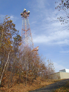
The historical description leads reliably to the station and the two reference marks. Powerpole #9550301 still exists, but the 30-inch oak tree was not found. The station mark and both reference marks were found as described. The ATT microwave tower used for the azimuth (located near LY2774 triangulation station EVANS ET) is easily observed. There is no PID for this landmark station.
At the station a Garmin GPSmap76 receiver with active remote antenna was used to record WAAS-corrected coordinates which were identical to the adjusted coordinates listed on the NGS datasheet. All marks are well exposed, in good condition, and the stamped designations are legible. ~Rich in NEPA~


.")
| Designation | Status | Condition | Image |
|---|---|---|---|
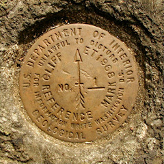
| CLIFF ET AZ MK | Recovered | Good |
|
| CLIFF ET RM 1 | Recovered | Good |
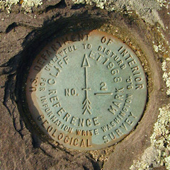
|
| CLIFF ET RM 2 | Recovered | Good |
|