10-36-0011-12
10-36-0011-12
Spatial/elevation data
| Coordinates | N 41.40545° W 75.660283° |
| Elevation | 778.60 ft. |
| Location | Pennsylvania
Lackawanna County Scranton Quad |
Mark description
| Type | Elevation Mark |
| Setting | Bridge Abutment |
| Monumented | 2010 by PA Dept. of Highways |
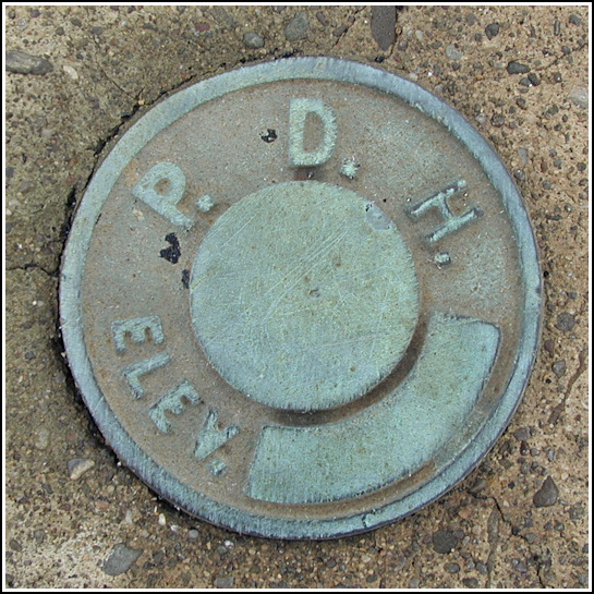
| Description (PA Dept. of Highways) | The station is located on the overhead pedestrian foot bridge over SR 0011. The station is a PDH disk in top northwest corner of bridge wing/abutment wall. Please see: 10-36-0011-12. |
Narrative and photographs
Original narrative: Surprise! Out for a walk one Sunday evening at work, I wandered over to the railroad bridge over Jefferson Avenue intending to check on S 288 and poke around the Lackawanna Station Hotel. On the way I noticed a small, red-painted, boarded-up booth on the north side of the tracks that I had to investigate. Nothing too intriguing there (I assume it was an old ticket booth of some kind), but as soon as I turned around I spotted a familiar blue-green disk on the northwest corner of the bridge abutment.
This is yet another unstamped PDH disk. Because it has no stamping, and I’m unable to find a datasheet for this mark, its designation and date remain unknown. The date “1969” is stamped into the concrete retaining wall adjacent to the mark.
Update (May 30, 2012): During a walk around town as part of our staff “retreat,” I detoured Elaine over to the bridge so that she could see this benchmark (as well as S 288). I was surprised to see that it is now stamped similarly to many other PDH marks I’ve found in the past few years.
Update (May 21, 2014): I’ve located the datasheet on PennDOT’s Photogrammetry Asset Management System website, so I’ve filled in the appropriate values above. Note that while the disk was in place for years before, the official date of establishment of this mark (as it was surveyed by PennDOT) is 2010.
")

 and the mark (indicated).")

