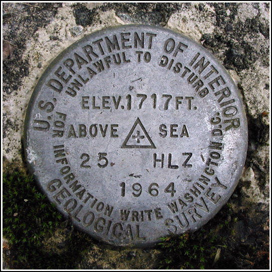
25 HLZ
25 HLZ
Spatial/elevation data
| Coordinates | N 41.1624° W 75.528817° |
| Elevation | 1716.653 ft. |
| Location | Pennsylvania
Monroe County Stoddartsville Quad |
Mark description
| Type | Bench Mark Disk |
| Setting | Concrete Culvert |
| Monumented | 1964 by USGS |
| Description (USGS) | Brady’s Lake; 40 ft NW. of Brady’s Lake sign; 15 ft NW. of gate; 10 ft N. of, and 0.1 ft lower than centerline of 24-in pipe culvert; in N. end of E. abutment; standard tablet stamped “25 HLZ 1964 1717”. Elev. 1717.653 ft. |
USGS recovery information
View reportNarrative and photographs
Today one unexpected find (15 C) in Clifton was followed by another at Bradys Lake. Still determined to find an easy way to access the old railbed, we followed Route 2013 all the way to Route 215 and eventually to Route 940, and then followed Bradys Lake Road straight north toward the dam. Roundabout, but it’s really the only way to approach the lake. When we arrived in the parking lot, Rich indicated that there was another benchmark very close by - within forty feet, according to the coordinates he had pulled from the map. Those coordinates were quite good and after a few moments of searching I spotted the disk on the corner of a culvert passing beneath the road over the dam. A thick layer of asphalt has been cut back to reveal the mark. Nearby we noticed the baseline markers and pink-flagged stakes from recent survey work. I suspect that this mark may have been involved in the survey, although there was no solid evidence of this. The Bradys Lake sign is now missing, though its frame remains in place.


