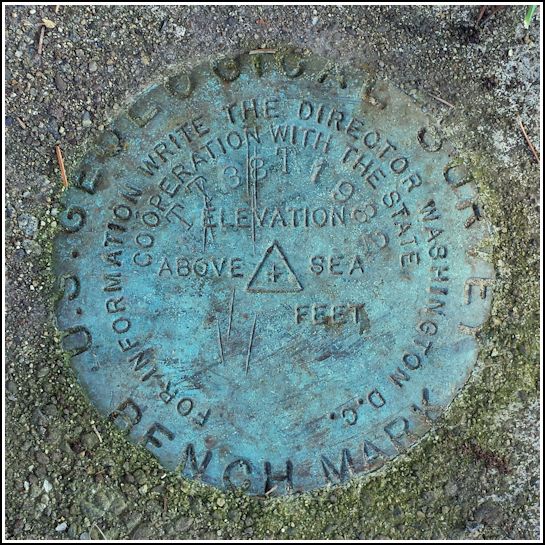
TT 38 T
TT 38 T
Spatial/elevation data
| Coordinates | N 41.458702° W 75.728771° |
| Elevation | 1487.460 ft. |
| Location | Pennsylvania
Lackawanna County Scranton Quad |
Mark description
| Type | Transit Traverse Station Disk | ||||||
| Setting | Concrete Post | ||||||
| Monumented | 1932 by USGS | ||||||
| Description (USGS) | (Vertical): Clarks Summit, 3.0 mi SW. of; 3.0 mi NE. of Milwaukee; on Newton Turnpike leading over Bald Mountain; 27 ft S. of crossroad; rd. SW. abandoned; on property of Carson Estate; in concrete post; standard tablet stamped “TT 38 T 1932”. Elev. 1487.460 ft. (Horizontal): Clarks Summit, 3 mi SW. of; 3 mi NE. of Milwaukee; on Newton turnpike over Bald Mountain; 27 ft S. of crossroads (rd. SW. abandoned); on property of Corson estate; in concrete post; standard tablet stamped “TT 38 T 1932”
|
Narrative and photographs
Several years ago, I was intrigued by the mention of a “Corson estate” in the mark’s description on the horizontal mark datasheets. No one I asked had any idea who these “Corsons” were. I went on at least one scouting expedition, but I was expecting the mark to be located on Bald Mountain Road, and I found nothing.
While idly browsing the topo map a few weeks ago, I noticed a BM at the intersection of Summit Lake Road and Forest Acres Drive. I looked up its elevation on my vertical datasheets and was surprised to see that the “Corson estate” mark was also listed there, although the spelling of the name on the vertical datasheets was “Carson.” (I had never checked the vertical sheets before, assuming that TT 38 T was only a horizontal mark since I didn’t see any BMs on the map in the expected location.) Still, my interest in searching for this mark was renewed.
Tonight, as Rich and I passed the yard of the house nearest the T-intersection, we simultaneously spotted the disk set in the top of a small concrete post, flush with the ground and just inches from a small rose bush. We noticed a small child in the kitchen window and presumed that an adult would be at home, so we decided to stop and ask for permission to document the mark.
The young blonde woman who came to the door had no idea of the existence of the mark, which I found odd, but I explained briefly what it was and how cool it was that she had one in her yard. I also asked her if she knew anything about the Corson/Carson estate mentioned in the description. She didn’t, but she suggested that the intended name might have been “Cosner” instead. “That’s called Cosner Corners,” she said, pointing toward the T-intersection. When I looked at the map later, I noticed that Cosner Cemetery is just down the road, too, so it seems likely that she is correct.
The disk is in good condition in the front yard of 1702 Forest Acres Drive. It is in danger of becoming obscured, but certainly not damaged, by the nearby rose bush. While Forest Acres Drive apparently was once called the Newton Turnpike, the description “leading over Bald Mountain” is deceptive.


