TT 34 T
TT 34 T
Spatial/elevation data
| Coordinates | N 41.5196° W 75.58661° |
| Elevation | Unknown |
| Location | Pennsylvania
Lackawanna County Carbondale Quad |
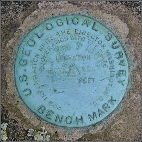
Mark description
| Type | Transit Traverse Station Disk | ||||||
| Setting | Rock Outcrop | ||||||
| Monumented | 1932 by USGS | ||||||
| Description (USGS) | Montdale, 1.7 mi SE. of; 3.0 mi NW. of junction of US Highway 6 and State Highway 247 at Peckville; in saddle at top of mountain; 26 ft NE. of centerline of hwy.; in large rock outcrop; standard tablet stamped “TT 34 T 1932”
|
Narrative and photographs
It’s always exciting when I’m idly reading through datasheets and discover a “new” mark—particularly when it’s close to home, and when we pass by it all the time, unaware! Stations that serve as horizontal control tend to surprise us more often because, other than the ET (electronic traverse) marks, most of them do not appear on topo maps. Last night I happened to read the description for this mark and was just about shocked to see that there is a mark along Route 247 (“the Wildcat”), which we travel at least a few times per week. A glance at Google Street View showed us that the mark should be set on one of the rock outcrops directly in front of the billboard for Laura’s Pizza & Hoagies, although we couldn’t actually see the mark in the Street View frames.
This Memorial Day morning, on our way to search for a few other bench mark disks in the Daleville and Gouldsboro areas, Rich and I stopped to search for this one. We found it quickly, set into one of the suspected rock outcrops. In a way, I still can’t believe that we hadn’t at some point noticed it when driving by, but it is well above eye level. Now that we know where to look, of course, this bright blue disk will stand out to us every time we pass by.
The disk is in good condition with legible stamping. It is solid in its setting and far enough off the highway that it’s probably not in much danger from traffic or construction.


