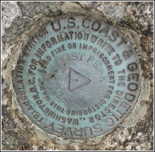
WEST PEAK (PE1905)
WEST PEAK
Spatial/elevation data
| Coordinates | N 44.302533° W 68.372233° |
| Elevation | 1070 ft. |
| Location | Maine
Hancock County Southwest Harbor Quad |
Mark description
| Type | Triangulation Station Disk |
| Setting | Bedrock |
| Monumented | 1934 by NGS |
| Description (NGS) | NGS Datasheet |
NGS recovery information
Descriptive text
The station and both reference marks were recovered in good condition. The marks are located on Bernard Mountain in Acadia National Park. The station was reached via the West Ledge Trail. The summer house mentioned in the 1934 note no longer exists, but its anchors are still evident on the bedrock ledge. Autonomous (non-corrected) handheld GPS coordinates for RM 1 are 44 18 08.9(N) 068 22 20.0(W). Autonomous (non-corrected) handheld GPS coordinates for RM 2 are 44 18 09.1(N) 068 22 20.1(W).Narrative and photographs
Rich and I found this mark’s original to-reach to be quite confusing. I have a good feeling that the “town dump” is long gone, and I also wonder what kind of a “traffic circle” ever existed in this maze of unimproved narrow gravel roads. In the interest of time and sanity, Rich and I decided that we would not attempt to confirm or correct the to-reach this time, but would simply find our own way to the peak. The West Ledge Trail appeared to be somewhat longer (which generally means less steep) than the South Face Trail, and so our game plan was devised. We parked at a small 2-vehicle turnout along Western Mountain Road, almost to its western terminus at Seal Cove Pond, and found the West Ledge trailhead directly across the road.
When we emerged from a forested part of the trail, just a few hundred feet from the tri-station coordinates, we saw on the rock ledge before us four iron rods set out in a square, and a ring set into the rock at the midpoint. Could this have been the remains of the “small summer house built of native timber and chained to the rock”? The proximity to the station disk, and the fact that the direction checks as well, is strong evidence that it was. How neat! We were both thrilled to have discovered such an “artifact” and, thanks to the datasheet, to know what once stood there.
Rich and I walked right up to the station disk and found it to be in good condition, as was RM 1. They were both on bare rock, so they were obvious finds. RM 2 was difficult to find because it was buried beneath several inches of moss. Once we determined the proper location from the box score data, we rolled back the moss carpet (not as easy as it sounds) and Rich spotted the mark underneath. I wanted him to rest his knees while I took my photos of the marks; he rested for a minute and ate some peanut butter crackers, but was on his feet again soon to offer a helping hand with the photos. We have so much fun doing this together!

.")

| Designation | Status | Condition | Image |
|---|---|---|---|
| WEST PEAK RM 1 | Recovered | Good |
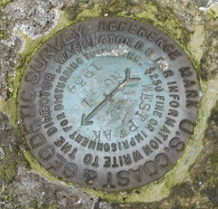
|
| WEST PEAK RM 2 | Recovered | Good |
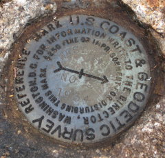
|