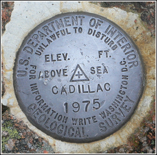
CADILLAC
CADILLAC
Spatial/elevation data
| Coordinates | N 44.353028° W 68.225389° |
| Elevation | Unknown |
| Location | Maine
Hancock County Seal Harbor Quad |
Mark description
| Type | Electronic Traverse Station Disk | ||||||
| Setting | Rock Outcrop | ||||||
| Monumented | 1975 by USGS | ||||||
| Description (USGS) | Bar Harbor, 2.5 mi SSW. of; 3.4 mi NNE. of Seal Harbor; at crest of Cadillac Mtn.; in Acadia National Park; about 0.2 mi NE. of old NGS triangulation station “Mt. Desert”; on N. face of mtn. near large parking area; 54 ft W. of W. end of concrete sidewalk of North Parking area; 26 ft N. and 5 ft higher than centerline of rd.; 4.6 ft higher than centerline of black top sidewalk; in outcrop about 4 ft N. of S. edge of rock outcrop; standard tablet stamped “CADILLAC 1975”
|
Narrative and photographs
After a very exciting morning and early afternoon of survey mark hunting, during which we found the complete set of FERNALD HILL 1870 marks and a large chiseled square and USGS disk near the Bubble Pond outlet, we took the long winding drive to the top of Cadillac Mountain. We’ve been wondering about the location of the eponymous CADILLAC station for a long time—it being completely distinct from and unrelated to, and nowhere physically close to, the disk that “everyone” finds at the summit (MOUNT DESERT RESET). This is actually the disk (with a few artistic liberties taken) that appears on the various benchmark pins, zipper pulls, and paperweights for Cadillac Mountain.
With plane coordinates taken from the USGS datasheet, and a little bit of luck and observational skills, we located it today! It is located along the northern part of the loop of the auto road at the summit, about 725 ft. NNE of MOUNT DESERT RESET, and on an outcrop about 4.5 ft. above the surface of the road. The disk is solid in its setting and in very good condition.

