PARKER 1870 (PE1898)
PARKER 1870
Spatial/elevation data
| Coordinates | N 44.353567° W 68.32663° |
| Elevation | 85 ft. |
| Location | Maine
Hancock County Southwest Harbor Quad |
Mark description
| Type | Copper Bolt |
| Setting | Rock Outcrop |
| Monumented | 1870 by NGS |
| Description (NGS) | NGS Datasheet |
NGS recovery information
Descriptive text
The station and both reference marks were recovered in good condition. The reference marks are situated as described in the 1944 recovery note. To reach the station from the junction of route 198 and route 102 in Somesville, follow route 102 south for 1.3 miles. Turn left onto Parker Farm Road and travel east for 0.36 miles to a fork. Bear right and travel 0.11 miles to another fork. Park and walk 0.14 miles east-northeast through open woods to the station. The knoll is now wooded and the blazed tree is not evident. Autonomous (non-corrected) handheld GPS coordinates for RM 1 are 44 21 12.8(N) 068 19 35.7(W). Autonomous (non-corrected) handheld GPS coordinates for RM 2 are 44 21 13.2(N) 068 19 36.0(W).Narrative and photographs
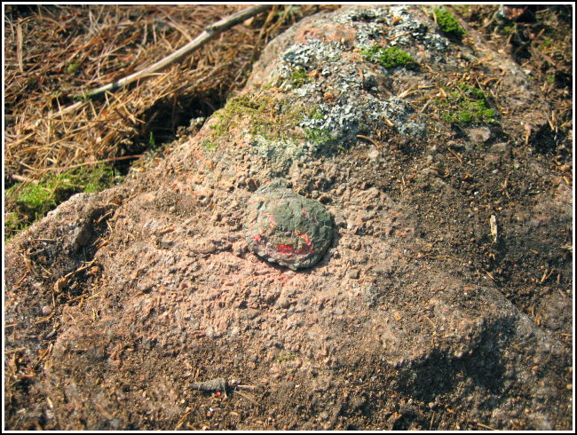
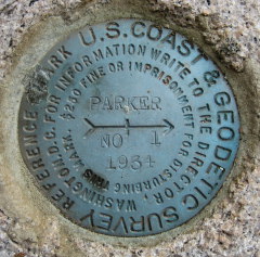
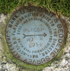
We began by turning from Route 102 onto Parker Farm Road. This gravel road led us east past turn-offs and driveways to quaintly named sea cottages, and eventually to within a tenth of a mile of the coordinates. Even though we were so close, we found the woods extremely difficult to pick our way through. The brush and fallen branches are twisted and sharp and grabbed at our legs when we tried to walk. A zigzagging route finally took us to the coordinates. To say that looking for a bolt in this jungle of fallen trees, pine debris and moss was like looking for a needle in a haystack would be an understatement. Fortunately we had reference marks to rely on (provided we could find them) and, as you might have suspected, the “huge boulder” referred to in the 1934 recovery note hadn’t moved an inch.
Within minutes, Rich had located RM2 on a prominent boulder while I stumbled my way slightly downhill and spotted RM1 on a similarly obvious outcropping. Neither of us could see the station very well from our respective reference mark, but Rich was able to walk a line on the bearing indicated by RM2’s arrow toward the station. I crouched down and followed my reference mark’s bearing line with my eyes, and told Rich to stop walking as soon as he crossed it. “Look there,” I said. At his feet, beneath a fallen log, was a perfect little outcropping boulder and, beneath the moss, the bolt set in 1870. The reference marks had served their purpose! What an exciting find!


| Designation | Status | Condition | Image |
|---|---|---|---|
| PARKER 1870 RM 1 | Recovered | Good |
|
| PARKER 1870 RM 2 | Recovered | Good |
|