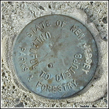
NJDPF(2)
Recovered in Good Condition on January 20, 2006
Spatial/elevation data
| Coordinates | N 41.143483° W 74.31235° |
| Elevation | Unknown |
| Location | New Jersey
Passaic County Greenwood Lake Quad |
Mark description
| Type | Unspecified Disk |
| Setting | Square Concrete Monument |
| Monumented | Unknown by New Jersey Division of Parks and Forestry |
| Description (New Jersey Division of Parks and Forestry) | Unavailable. |
Narrative and photographs
Just a few hundred feet along the Sterling Ridge trail from NJDPF(1), we spotted this disk. The two disks are identical, having no apparent designation or other identifying features. This 2-inch disk is set in a concrete monument projecting about 4 inches above ground level. This disk is just east of the northern wall (now in ruins) of the Old Long House.

