BULL HILL RESET (LX4373)
BULL HILL RESET
Spatial/elevation data
| Coordinates | N 41.438354° W 73.95596° |
| Elevation | 1421 ft. |
| Location | New York
Putnam County West Point Quad |
Mark description
| Type | Triangulation Station Disk |
| Setting | Rock Outcrop |
| Monumented | 1933 by NGS |
| Description (NGS) | NGS Datasheet |
NGS recovery information
Descriptive text
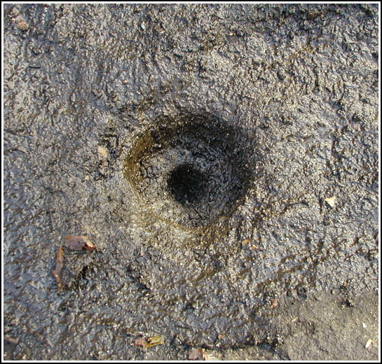
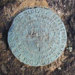
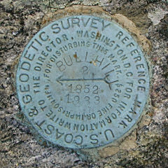
The station was recovered in poor condition. The disk has been removed, leaving only a drill hole and impression in the rock outcrop, as noted in the 1951 recovery. Reference mark 1 was recovered in fair condition with scratches on the face of the disk. The stamping is still legible. Reference mark 2 was found in good condition. The station is located along the Washburn Trail in Hudson Highlands State Park. The most direct route is to park along Route 9D at the trailhead of the Cornish Trail. Follow the Cornish Trail for several hundred feet to its intersection with the Washburn Trail, then follow the Washburn Trail in a generally northeasterly direction to the station near the high point of the ridge. Handheld GPS coordinates for RM 1 are 41 26 17.9(N) 073 57 21.3(W). Handheld GPS coordinates for RM 2 are 41 26 18.0(N) 073 57 21.7(W).Narrative and photographs
Rich, Aaron and I had an awesome-weather day for November! Today’s goal was a 6-mile circuit hike to the summit of Bull Hill (~1200 feet above the parking spot!) via the Lone Star, Washburn, Undercliff, Nelsonville and Split Rock trails. In addition to finding two geocaches, we also searched for and recovered the BULL HILL RESET tri-station.
We had no trouble locating the marks—or, in the case of the station disk—what evidence remains of the mark. The drill hole that held the station disk is evident at the adjusted datasheet coordinates, but the entire disk is gone, leaving just the hole and an impression of the disk on the surrounding boulder. Both reference marks were found intact on nearby outcropping bedrock. RM 1 is damaged, showing scratches across its surface and a possible attempt to pry it up. Nevertheless the stamping is mostly legible. RM 2 is in very good condition.
Not much can beat the combination of a warm, perfectly blue-sky November day, a hike, geocaches and survey mark hunt with good friends!
 on the rock outcrop.")

| Designation | Status | Condition | Image |
|---|---|---|---|
| BULL HILL RM 1 | Recovered | Fair |
|
| BULL HILL RM 2 | Recovered | Good |
|