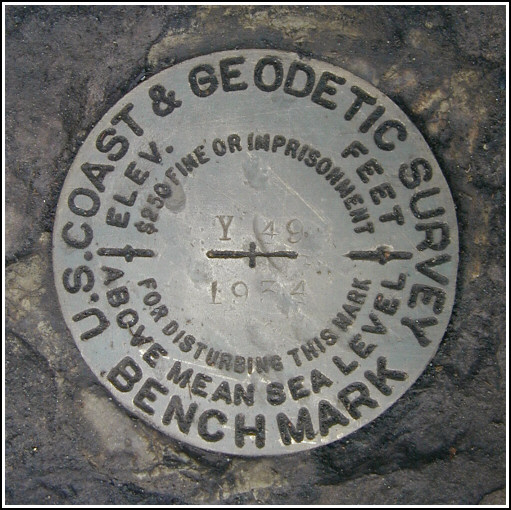
Y 49 (LZ0103)
Y 49
Spatial/elevation data
| Coordinates | N 41.384233° W 76.1441° |
| Elevation | 1371.20 ft. |
| Location | Pennsylvania
Wyoming County Dutch Mtn Quad |
Mark description
| Type | Bench Mark Disk |
| Setting | Bridge Abutment |
| Monumented | 1934 by NGS |
| Description (NGS) | NGS Datasheet |
NGS recovery information
Descriptive text
The mark was recovered in good condition. This part of the old Lehigh Valley Railroad bed is now an access road in PA State Game Lands No. 57 and is easily passable by vehicle.Narrative and photographs
Rich and I picked up another companion for today’s adventures, which involved finding the nearby geocache “The Stack.” After an exhilarating hike that involved wading through an icy stream and some very steep and slippery climbing, Aaron might have been almost relieved that our only other plan for the day was to hunt for this benchmark.
On our way back to the car from the cache site, we took a slightly different route and emerged on the road to the southwest of the creek, which this time we crossed easily on this old railroad bridge. (Yes, I felt embarrassed.)
Our first inspection of the bridge abutments revealed nothing but plentiful brush that needed to be cleared, so we returned to the car for tools. Rich was in the process of clearing the brush when a ranger appeared behind us. He asked gruffly whether we were “cutting down trees in the gamelands" but we assured him we were only clearing a small area on the bridge abutment so that we could find and photograph the mark. He was not very interested in our explanation of the history and importance of benchmarks, and he soon left us alone.
The mark is set in the stone abutment exactly as described, and at the time of our visit was in good condition. The stamping is worn but the designation is still quite clear and the date can be read with some effort.


N 41° 23.053’ W 076° 08.643’
Recovered in good condition.
This second order vertical control station is set in the top of a stone abutment for a former railroad bridge. The bridge spans Cider Run, and the old railroad bed which parallels Bowman Creek southwest from Noxen now serves as an access road within PA State Game Lands #57. The historical description leads reliably to the station. At the station a Garmin GPSmap76 receiver with remote active antenna was used to record WAAS-corrected coordinates which were 120 feet from the scaled coordinates listed on the NGS datasheet. The mark is well exposed, in good condition, and the stamped designation is readable upon close inspection. ~Rich in NEPA~


