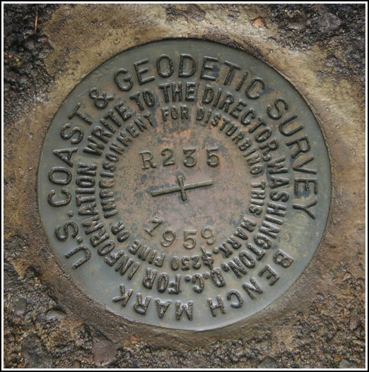
R 235 (LY1155)
R 235
Spatial/elevation data
| Coordinates | N 41.33835° W 75.131283° |
| Elevation | 1537.45 ft. |
| Location | Pennsylvania
Pike County Promised Land Quad |
Mark description
| Type | Bench Mark Disk |
| Setting | Concrete Step |
| Monumented | 1959 by NGS |
| Description (NGS) | NGS Datasheet |
NGS recovery information
Descriptive text
Recovered in good condition. The mark is located approximately 120 yards south along PA Route 402 from a private road leading southwest. The apple tree no longer exists.Narrative and photographs
This proved to be an exciting find! I love coming across manmade structures in the woods. We began our search too far north at a private road leading to some hunting cabins. We soon determined it was unlikely that a house had ever stood at this location, and we walked south on PA Route 402 for just over 100 yards until on our right we noticed a level area covered in young pine growth. Entering the woods at this point, we saw the steps immediately, and off to their right was a decrepit stone foundation filled—and surrounded—with old glass bottles, rusted cans, and other junk such as a child’s rusted bed mattress. The mark was found on the steps exactly as described, and it appears to be in excellent condition with all stamping legible.


N 41° 20.305’ W075° 07.878’
Recovered in good condition.
This second order vertical control station is set in the center of the top surface of the second step of an old concrete stair platform along U.S. Rt. 402, roughly 120 yards south of a private woods road west. The historical description is still usable, but the apple tree no longer exists. At the station a Garmin GPSmap76 receiver with remote active antenna was used to record autonomous (non-corrected) coordinates which were 380 feet from the scaled coordinates listed on the NGS datasheet. The mark is well exposed, in good condition, and the stamped designation is clearly legible. ~Rich in NEPA~


