CAMELBACK (LY2688)
CAMELBACK
Spatial/elevation data
| Coordinates | N 41.0422968° W 75.3541149° |
| Elevation | 2131 ft. |
| Location | Pennsylvania
Monroe County Mount Pocono Quad |
Mark description
| Type | Triangulation Station Disk |
| Setting | Rock Outcrop |
| Monumented | 1958 by NGS |
| Description (NGS) | NGS Datasheet |
NGS recovery information
Descriptive text
The station, both reference marks, and the azimuth mark were recovered in fair condition. The station disk is pitted and illegible, but appears to be solid in its setting. The description is accurate with the following exceptions. Note that RM 2 is east, not west, of the fire tower. The speed limit sign and witness post for the azimuth mark were not found. The azimuth mark is 27.5 feet south of the centerline of the road and 3.5 feet south-southwest of a 14-inch diameter pine tree. Autonomous (non-corrected) handheld GPS coordinates for RM 1 are 41 02 32.3(N) 075 21 06.6(W). Autonomous (non-corrected) handheld GPS coordinates for RM 2 are 41 02 32.5(N) 075 21 07.0(W). WAAS-corrected handheld GPS coordinates for the azimuth mark are 41 02 38.2(N) 075 21 43.0(W).Narrative and photographs
It’s been four years since I last visited this spot, and all along I’ve been curious about RM 2 and the azimuth mark. My inexperience was probably a large factor, but I was still curious how I could have missed them my first time around. On this sunny Thursday, Rich and I decided to find out. After photographing the fire tower (LY2687), we moved on to the CAMELBACK station.
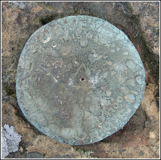
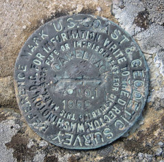
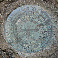
We reached the main station disk with little difficulty once we found a way through the rocks and brush in the area. The disk is not stamped, and it has seen better days. It’s suffered some weathering as well as possible vandalism. RM 1 was also an easy find, probably because I’d been there before. But RM 2 was a different story. At the time of my first visit, I had been unaware of the datasheet “box score” and was merely following the written directions on the datasheet, which place RM 2 west of the fire tower. Today we discovered that it’s actually east of the tower—so I was searching on entirely the wrong side! We found the mark easily once we recognized the mistake that had been made.
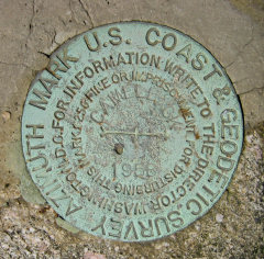
After a grueling and unsuccessful (but still enjoyable!) hike toward TANNER (LY2686) and back, we decided to search for the CAMELBACK azimuth mark. According to the description it’s conveniently located right along the road down the mountain—on our way out of the park. We drove slowly, seeing nothing exciting for a few minutes. Then I spotted a large boulder off to my left, and immediately stopped the car and hopped out. It was a long shot, and I was surprised to see the azimuth disk sitting right on top of the boulder! Finally my quest was complete. Like the reference marks, the azimuth mark disk was in good condition with legible stamping.
.")
| Designation | Status | Condition | Image |
|---|---|---|---|
| CAMELBACK AZ MK | Recovered | Good |
|
| CAMELBACK RM 1 | Recovered | Good |
|
| CAMELBACK RM 2 | Recovered | Good |
|