HIGH TOR BEACON (LX4216)
HIGH TOR BEACON
Spatial/elevation data
| Coordinates | N 41.18763° W 73.96535° |
| Elevation | 823 ft. |
| Location | New York
Rockland County Haverstraw Quad |
Mark description
| Type | Landmark/Intersection Station |
| Setting | Airway Beacon |
| Monumented | 1932 by NGS |
| Description (NGS) | NGS Datasheet |
Narrative and photographs
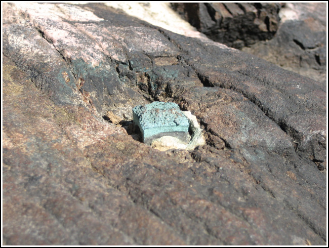
Rich and I were excited to explore High Tor today, not only for the chance to hike in a new and scenic area, but also for the possibility of finding some old tri-stations, or at least satisfying our curiosity regarding the datasheet description of the High Tor Beacon. This mark and HIGH TOR RESET (LX4218) are intriguing marks with intertwining and equally confusing histories. What is actually referred to by this PID? Is it the tower, as indicated in the 1932 monumentation note? Or the Army Corps of Engineers map control station mentioned in the 1964 recovery? It seems these points should have required two separate PIDs, or at the very least a note indicating that the map control station was set directly beneath the center of the tower. We can’t even discern from the datasheet whether the disk truly was set at the center point of the tower; if not, a new record for the map control station definitely would be required. The datasheet for LX4218 has little to add, except that the map control disk mysteriously appeared at some point between 1938 and 1964. Unfortunately, this time even seeing the site firsthand did little to clear up the confusion.
After just a few minutes of searching, we were able to locate the steel tower footings, as well as a squared-off chunk of brass (very likely a broken or cut disk) cemented in bedrock near the center of the square formed by the beacon footings. It is our hypothesis, as well as that of an NGS contributor from 2005, that this piece of brass is what remains of the Army Corps map control station.

