MUD
Spatial/elevation data
| Coordinates | N 41.1165° W 74.885616° |
| Elevation | 1604 ft. |
| Location | New Jersey
Sussex County Flatbrookville Quad |
Mark description
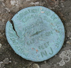
| Type | Geodetic Control Survey Disk |
| Setting | Rock Outcrop |
| Monumented | 1937 by NGS |
| Description (NGS) | NGS Datasheet |
NGS recovery information
Descriptive text
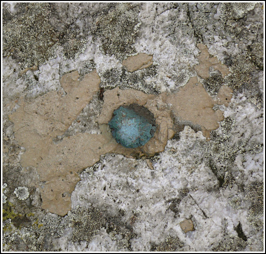
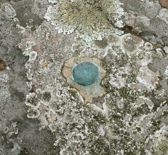
The station and reference mark 1 were recovered in poor condition and reference mark 2 was recovered in fair condition. Although all three marks were described as disks in the 1937 monumentation note and the 1940 recovery note, the station and reference mark 1 appear to have been damaged to the point where only their centers remain. They resemble bolts more than broken disks. Reference mark 2 is still marked by a disk, although it is damaged, with a crack running through its upper left quadrant. All three marks are securely set into the rock ledge. The site is most easily reached via the Appalachian Trail, beginning from the Crater Lake parking area. Handheld GPS coordinates for RM 1 are 41 06 59.6(N) 074 53 08.0(W). Handheld GPS coordinates for RM 2 are 41 06 59.6(N) 074 53 08.7(W).Narrative and photographs
MUD was an easy find with some unusual characteristics. I’m not sure what possessed us to travel to the Delaware Water Gap NRA on this brutally cold December day, but we were intrigued by MUD and figured searching for benchmarks would be a fine activity for the day. The station is located on a high ridge reminiscent of the granite ridges we hike in Maine, complete with small pines and strong winds. We hiked from Skyline Drive along the AT and a gravel road remaining from a proposed subdivision (acquired by the federal government in the 1960s-1970s for the Tocks Island Dam project). Once up on the ridge, our GPSr led us directly to the station—or what remains of it.
Both the original 1937 description and the recovery three years later specify that standard disks were used for the station and both reference marks. However, RM 2 was the only point we found marked by a disk. Broken-off disks leaving nothing but the shank and piece of the middle of the disk are nothing unusual, but what we found at the coordinates for both the station and RM 1 resembled bolts much more than damaged standard-sized disks. We are still not sure what to conclude. RM 2’s disk is also damaged, with a crack running through its upper left quadrant. Nevertheless, all three markers seem to be secure in their settings.
We agreed that on a warm day this could be a lovely spot for a picnic (despite the name of the station, we did not find any MUD here). But today was much too blustery, so after taking our photos and documenting our find we headed back to the car and onward with the rest of the day’s adventures.
Although this particular mark doesn’t appear to be included in the report, learn more about the 1937 NJGCS survey here: Bulletin 46: Work of the New Jersey Geodetic Control Survey, c. 1938


| Designation | Status | Condition | Image |
|---|---|---|---|
| MUD RM 1 | Recovered | Fair |
|
| MUD RM 2 | Recovered | Good |
|