WARNER NJGS (LY2636)
WARNER NJGS
Spatial/elevation data
| Coordinates | N 41.152616° W 74.901566° |
| Elevation | 679 ft. |
| Location | New Jersey
Sussex County Lake Maskenozha Quad |
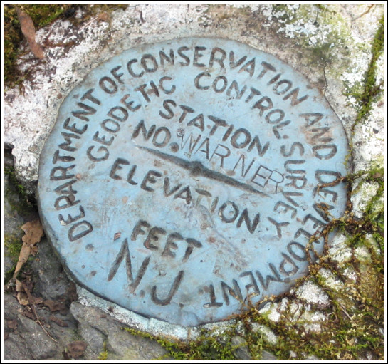
Mark description
| Type | Geodetic Control Survey Disk |
| Setting | Rock Outcrop |
| Monumented | 1938 by New Jersey Geological Survey |
| Description (NGS) | NGS Datasheet |
NGS recovery information
Descriptive text
The station disk was recovered in good condition. Neither RM 1 nor RM 2 was recovered. The station is approximately 30 yards northwest of a track road leading north to a fenced-in concrete block house with radio mast. The station is approximately 9 feet northeast of the remains of the rock fence line. A new to-reach follows. From Wallpack Center, take NPS Route 615 South for 1.3 miles. Bear right onto Pompey Rd. (gravel) at 41 08 46.9(N) 074 53 44.3(W) and follow this road 0.3 mile to a gravel road northwest at 41 08 40.1(N) 074 54 06.3(W). Turn right (northwest) onto gravel road and follow 0.4 mile to a T intersection. Go right on farm road for 0.2 mile to track road left. Follow track road 0.2 mile to top of knoll and station on left.Narrative and photographs
Making our way to WARNER turned out to be quite an adventure! A September investigation into the datasheet to-reach was a dead end as it led only to a gated (and possibly impassable) road. Today Rich and I decided to attack the problem from a different direction. After a fun afternoon spent poking around Millbrook Village, where we also recovered LY0748, we headed north along the Old Mine Road toward Flatbrookville. Passing Smith Ferry (and a possible entry point for our upcoming hike to GIRR (LY2633) we made our way toward WARNER from the west. According to our topo map, a road should have led from N 41°08.546’ W074°54.878’ directly to the Warner farm, but we could find no sign of a road heading east at that point. We continued east along Pompey Rd. and another avenue soon presented itself at N 41°08.660’ W074°54.114’. This gravel access road intersected a farm road that in turn led us directly to abandoned fields and buildings—what we presume to have been the Warner farm.
A quick bushwhack to the top of the knoll (where we emerged onto a track road that we could have driven to the top) and we were closing in on the station. We followed the remains of the rock fence about thirty yards northwest through the thorns and brush, and the mark was at our feet. Unfortunately, our best efforts at finding the reference marks were unsuccessful. Without measurements or diagrams, we had almost nothing on which to base our search. We couldn’t even find another piece of outcropping bedrock anywhere nearby.
The station disk is in good condition, and this was the first time we’ve seen a “NJ Department of Conservation and Development” disk.
Intriguing historical detective work in a scenic area is one of my favorite activities for an unseasonably warm December day such as this, and discovering new roads and abandonments along the way is always a special treat. Dinner at the Walpack Inn afterward was a delicious ending to the day, as usual!


| Designation | Status | Condition | Image |
|---|---|---|---|
| WARNER NJGS RM 1 | Not Found | Unknown (Not Found) |

|
| WARNER NJGS RM 2 | Not Found | Unknown (Not Found) |
|