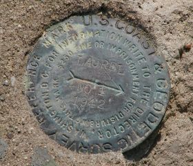
LAUREL

Spatial/elevation data
| Coordinates | N 41.357375° W 74.694397° |
| Elevation | 420 ft. |
| Location | New York
Orange County Port Jervis South Quad |
Mark description
| Type | Triangulation Station Disk |
| Setting | Round Concrete Monument |
| Monumented | 1942 by NGS |
| Description (NGS) | NGS Datasheet |
Narrative and photographs
Unfortunately, the gravel parking area is now paved, and this benchmark was either removed or paved over.
Note: June 12, 2003, in response to geocachers who claimed to have found the mark:
Until I see evidence to the contrary (and I hope I do!), I’m not convinced the station mark has been found recently. Reference mark #1 does still exist, but to claim a find the triangulation station disk itself should be located.”
(Recovered on June 27, 2003)
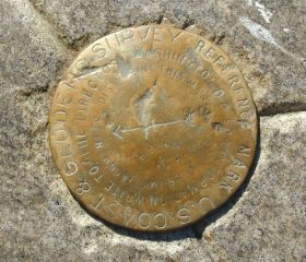
This triangulation station mostly likely is still viable, but the station mark itself appears to have been paved over. The historical descriptions leads reliably to the site. I can not log it as a find since I did not actually see the station mark and can not comfirm its existence. Reference mark #1 exists and is located roughly four feet northwest from the edge of the paved turn-around, and west-southwest of the southernmost end of the cemetery. The reference disk is in good condition, well exposed and the stamped designations are legible. Reference mark #2 is listed in the database separately as LY2604. ~Rich in NEPA~
| Designation | Status | Condition | Image |
|---|---|---|---|
| LAUREL RM 1 | Recovered | Good |
|
| TRI STATES 1942 | Recovered | Good |
|