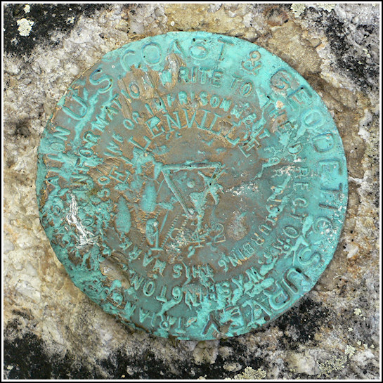
ELLENVILLE (LY2466)
ELLENVILLE
Spatial/elevation data
| Coordinates | N 41.7199° W 74.367683° |
| Elevation | 971 ft. |
| Location | New York
Ulster County Napanoch Quad |
Mark description
| Type | Triangulation Station Disk |
| Setting | Boulder |
| Monumented | 1942 by NGS |
| Description (NGS) | NGS Datasheet |
NGS recovery information
Descriptive text
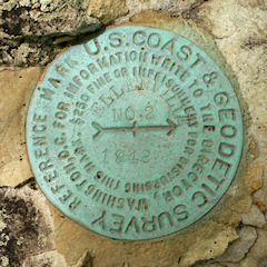
The station and reference mark 2 were found in good condition. They are located in the northernmost section of Sam’s Point Preserve on property managed by the Nature Conservancy. Start in Berme Road Park (41 42 48.3(N) 074 22 57.6(W)) and follow the Old Smiley Carriageway northeasterly approximately 1.4 miles to station. Reference mark 1 was searched for but not found. It may be buried beneath accumulated soil and roots. The azimuth mark was searched for but not found. The swimming pool at Ellenville High School is now abandoned and fenced off. No sign of the mark could be found along the edges or corners of the concrete sidewalk. Handheld GPS WAAS-corrected coordinates for RM 2 are 41 43 11.3(N) 074 22 04.1(W).Narrative and photographs
Our first investigation into this group of survey marks took place at the high school building. Supposedly, the azimuth mark was set into the northeast corner of the concrete apron surrounding the school’s swimming pool. I didn’t have high hopes. With a little trouble we located the old pool, which had apparently been used as a community pool before being abandoned outright some time ago. We circled the pool, checking all of the concrete areas but focusing on the northeast corner. This corner was, of course, one of two corners on the side of the pool with newer concrete than that surrounding the rest of the pool. The azimuth mark has apparently been removed or covered over when the new concrete was poured. We searched anyway for good measure, digging and sweeping away the leaves packed into the corner as best we could from outside the wire fence. We found nothing. Then Rich and I headed to the parking area at Berme Road Park and soon after began our hike to the station mark.
The old carriageway was very rocky and rutted, steep in spots. After a switchbacking climb of about 1.4 miles we reached the hairpin turn, the coordinates, and the station set into a boulder alongside the trail. Some sort of a pipe or segment of a pole is set into the boulder a few inches from the station disk; its purpose remains a mystery.
As usual, we quickly surveyed the woods for large boulders with disks set into them. In a matter of seconds we located RM 2, thanks in part to a pole—similar to the pole piece found near the station—that drew our attention.
Our efforts and experience didn’t help much with RM 1, though. While we eventually zeroed in on a likely boulder, it was much too overgrown to clear with the limited tools we had with us. Without our metal detector we couldn’t even be sure we had identified the correct boulder, but the box score measurements checked out and nothing else made much sense. I’m disappointed that we had to leave without recovering the entire set, but it happens. The “end of the world” message is no longer visible, although we found the outcropping on which it most likely had been painted.


| Designation | Status | Condition | Image |
|---|---|---|---|
| ELLENVILLE AZ MK RESET | Not Found | Unknown (Not Found) |

|
| ELLENVILLE RM 1 | Not Found | Unknown (Not Found) |
|
| ELLENVILLE RM 2 | Recovered | Good |
|