960 (LY1760)
960
Spatial/elevation data
| Coordinates | N 41.540833° W 75.534083° |
| Elevation | 959.52 ft. |
| Location | Pennsylvania
Lackawanna County Carbondale Quad |
Mark description
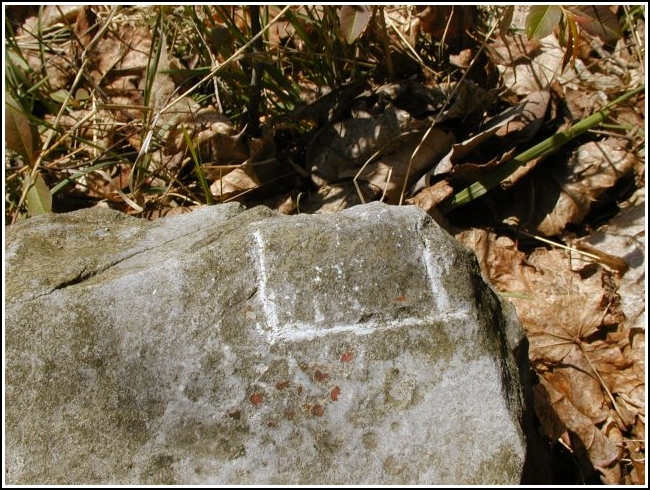
| Type | Chiseled Square |
| Setting | Bridge Abutment |
| Monumented | Unknown by USGS |
| Description (NGS) | NGS Datasheet |
Narrative and photographs
This was our final find of today’s benchmarking frenzy. Of the ones we’ve found so far, this was the simplest chiseled mark to locate. It’s just as Rich described it. After finishing up here, we rode a little further in Mayfield before turning back. Our tour was a wonderful way to ride a few miles, spend a beautiful day in the sunshine with a good friend, and pick up a bunch of benchmark finds along the way. We encountered wild guys on quads, some other cyclists, a noisy parade, ignorant drivers, and peaceful spots down by the river. Before going back home, I ate half the food in Rich’s house and crashed his computer, too. It was a great afternoon!

(Recovered on April 22, 2003)
N 41° 32.448’ W 075° 32.047’
This vertical control station is located along Chestnut Street in Mayfield. The historical description leads reliably to the station. As seems to be typical for many of these old railroad marks, there is some minor confusion with regard to the cardinal compass directions at the site. A well-defined chiseled square, approximately 2 inches by 2 inches, is easily discerned in the extreme west corner of the top surface of the first stone in the lowest visible tier of the northwest wing wall. At the station mark my Garmin GPSmap76 receiver indicated 64.9 feet from the NGS datasheet coordinates. ~Rich in NEPA~


