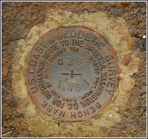
Q 288 (LY1569)
Q 288
Spatial/elevation data
| Coordinates | N 41.379367° W 75.551167° |
| Elevation | 1365.64 ft. |
| Location | Pennsylvania
Lackawanna County Olyphant Quad |
Mark description
| Type | Bench Mark Disk |
| Setting | Concrete Base |
| Monumented | 1961 by NGS |
| Description (NGS) | NGS Datasheet |
Narrative and photographs
At long last, I was granted a day off from work when it wasn’t raining! This Thursday the temperature bordered on warm and we actually saw some sunshine. Rich and I took advantage of the situation and headed out on our bikes toward Elmhurst, with the goal of taking a nice long (for me) ride and checking out the accessibility of several benchmarks along the old DL&W.
Of course, once I get within a mile of a benchmark I can’t resist the challenge. This one was quite a simple find. The signal is hard to miss, and the foundations, while crumbling, are still in place. It was easy to determine which part of the foundation held the mark, and Rich was the first to spot it. We both commented on what great shape the disk was in—certainly one of the more well-preserved ones I’ve found.


N 41° 22.762’ W 075° 33.070’
This vertical control station is about 2/3-mile northwest on the Steamtown Excursion line from the Rt. 435 overpass, and about 1/2-mile southeast from the I-84 overpass. The historic description leads reliably to the site. Access is excellent from along Front St. in Elmhurst. The signal structure and foundations still exist in various stages of deterioration. At the station mark my Garmin GPSmap76 receiver indicated 66.6 feet from the NGS datasheet coordinates. The disk is in very good condition, well exposed, and the stamped designations are legible. Zhanna and I biked up from Scranton to search for this together and we are sharing the find. ~Rich in NEPA~


