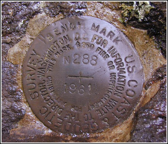
N 288 (LY1568)
N 288
Spatial/elevation data
| Coordinates | N 41.3933° W 75.5555° |
| Elevation | 1314.43 ft. |
| Location | Pennsylvania
Lackawanna County Olyphant Quad |
Mark description
| Type | Bench Mark Disk |
| Setting | Rock Outcrop |
| Monumented | 1961 by NGS |
| Description (NGS) | NGS Datasheet |
Narrative and photographs
Rich had no real plans to try for this one, but somehow I was able to convince him. Right beneath the I-84 bridge over Front Street, we hopped the rail (not as easy as it sounds when you’re lugging a bike) and made our way down to the tracks. After a nice bumpy ride past mile marker #125, we reached a rock cut. Of course, it wasn’t clear exactly what point was considered the south end of the rock cut, so we spent quite a long time searching up and down the length of the cut and rechecking our distances. I was beginning to doubt whether we’d find it today when I heard Rich call out “I found it!” And it was a great find. Somehow I’d walked right by it at least twice. The west rail no longer exists; this set of rails has been removed, but enough remains to determine their former position. Less than two feet above the mark, a spike wound in pink flagging tape is set into the rock. The disk is in excellent shape.


This vertical control station is a bit more than 1/2-mile NNW along the Steamtown Excursion line from the I-84 overpass. The historic description leads to the site but with considerable ambiguity. Access is fairly good from Front St. in Elmhurst, just underneath the I-84 bridges, or by continuing northward on the rails from LY1569. Mile marker #125 still exists. At the station mark my Garmin GPSmap76 receiver indicated 125.8 feet from the NGS datasheet coordinates. The disk is in very good condition, well exposed, and the stamped designations are legible. Zhanna and I biked up from Scranton to search for this together and we are sharing the find. ~Rich in NEPA~


