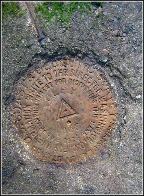
OLEY (LY1542)
OLEY
Spatial/elevation data
| Coordinates | N 41.0613° W 75.9092° |
| Elevation | 1207.83 ft. |
| Location | Pennsylvania
Luzerne County Freeland Quad |
Mark description
| Type | Triangulation Station Disk |
| Setting | Square Concrete Monument |
| Monumented | 1958 by NGS |
| Description (NGS) | NGS Datasheet |
NGS recovery information
Descriptive text
The station mark and reference marks 1 and 2 were recovered in good condition. The witness post and blazed trees were not found. A new route is required because the roads described are no longer passable by vehicle. The station may be reached on foot from the lower day-use area of Nescopeck State Park, but a stream crossing is necessary. If permission can be obtained, the best approach may be to park along the shoulder of Interstate 80 westbound and hike approximately 350 feet directly north to the mark.Narrative and photographs
What an adventure this was! After finding the geocache “x, y AND z” just a few miles to the north, Rich and I were in the mood to scout out the area for possible access to certain triangulation stations. We didn’t expect that we’d actually complete any hunts today, but once we realized that OLEY should be accessible from one of the designated parking areas for Nescopeck State Park, we decided to give it a try. We followed the main trail from the Lower Day-Use Area (this trail was likely once a road, probably that mentioned in the description) until reaching Nescopeck Creek. The sparse remains of bridges are evident where the road at one time crossed the creek, but they didn’t provide a suitable means for crossing it. We eventually crossed on a fallen log further north, and then backtracked down the eastern side of the creek to pick up the woods road once more (at the point where the bridge once carried it across). A trek uphill on this overgrown track road and then a short bushwhack through open woods brought us directly to the station. The station mark and RM1 were easy to spot, but measuring and digging through loose soil were required to expose RM2, which is now flush with the level of the ground. All marks are in good condition with clear stamping. Interstate 80 is just over 100 yards south of the mark and may provide the simplest means of access. I preferred the hike through the woods and the challenges it provided.


Recovered in good condition.
This second order triangulation station is situated in the new Nescopeck State Park, near the westernmost end of Mount Yeager, west of adjoining State Game Lands #187, southeast of Honey Hole Road, and just north of Interstate 80. At this time it was not determined whether the 1958 historical description is still reliable enough to follow. It’s unlikely that there are shorter and easier ways to reach this station at present.
The approach used in this recovery started at the park’s Lower Day-Use Area (entrance off Honey Hole Road at roughly N41° 03.97’ W075° 55.66’ and vehicle parking at roughly N41° 03.92’ W075° 55.63’), following the marked main trail on the left at the far end of the lot for about 0.6 miles, and eventually encountering Nescopeck Creek. There are remnants of cable bridges that once crossed the creek at roughly N41° 03.83’ W075° 55.06’. By continuing on the trail northerly a large blow-down tree was found spanning the creek (at roughly N41° 03.99’ W075° 55.02’) and was used to reach the opposite bank. Then, heading southerly along the eastern bank to the aforementioned bridge crossings and picking up a dim woods road heading south-southeast for roughly 100 yards before branching to the left on another dim woods trail heading southeast and east. This trail fades before reaching the station, and a moderately easy bushwhack for roughly 1/8 mile is necessary. A handheld GPSr made locating the station a very simple task.
The metal witness post no longer exists, nor do the two triangular-blazed trees referred to in the 1958 description. The station mark was partially obscured by leaf litter. Two steel nails were originally embedded in the top of the concrete monument to indicate the directions of the reference marks. One nail is missing, but its impression remains. RM1 was also partially obscured by duff and a mat of loamy soil and moss. RM2 was totally covered by a thick accumulation of loam, roots, moss and duff to such extent that it was necessary to measure the distance and direction from the station to find it. All monuments were cleared and the marks brushed clean. At the station a Garmin GPSmap76 receiver with active remote antenna was used to record autonomous (non-corrected) coordinates which were zero feet from the adjusted coordinates listed on the NGS datasheet. The station mark is in good condition, the reference marks are in very good condition, and all stamped designations are clearly legible. ~Rich in NEPA~


| Designation | Status | Condition | Image |
|---|---|---|---|
| OLEY RM 1 | Recovered | Good |
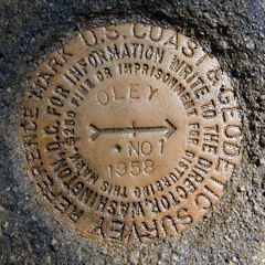
|
| OLEY RM 2 | Recovered | Good |
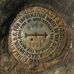
|