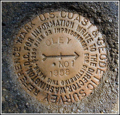
OLEY RM 1 (LY1543)
Recovered in Good Condition on September 21, 2003
Spatial/elevation data
| Coordinates | N 41.061333° W 75.908933° |
| Elevation | 1208.28 ft. |
| Location | Pennsylvania
Luzerne County Freeland Quad |
Mark description
| Type | Reference Mark Disk |
| Setting | Square Concrete Monument |
| Monumented | 1958 by NGS |
| Description (NGS) | NGS Datasheet |
NGS recovery information
Descriptive text
Reference mark 1 was recovered in good condition. The blazed trees were not found. A new route is required because the roads described are no longer passable by vehicle. The station may be reached on foot from the lower day-use area of Nescopeck State Park, but a stream crossing is necessary. If permission can be obtained, the best approach may be to park along the shoulder of Interstate 80 westbound and hike approximately 350 feet directly north to the mark.Narrative and photographs
For more information about this reference mark, see its parent mark OLEY.


Mark recovered in good condition.
Reference mark OLEY No. 1 is set in the top of a square concrete monument located approximately 80 feet east of the station. It is now well exposed, in very good condition, and the stamped designation is clearly legible. ~Rich in NEPA~


