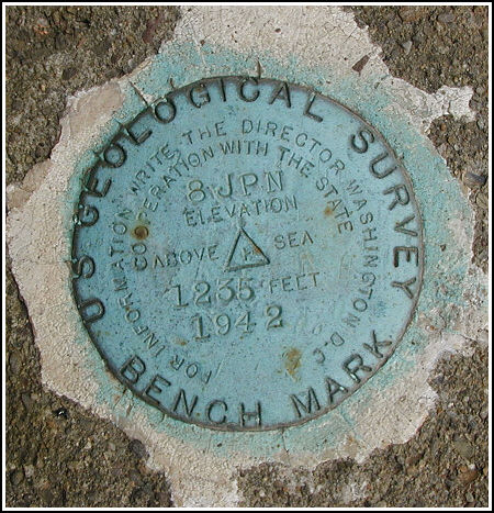
8 JNP (LY1532)
8 JNP
Spatial/elevation data
| Coordinates | N 41.1067° W 75.837266° |
| Elevation | 1234.15 ft. |
| Location | Pennsylvania
Luzerne County White Haven Quad |
Mark description
| Type | Bench Mark Disk |
| Setting | Bridge Wingwall |
| Monumented | 1942 by USGS |
| Description (NGS) | NGS Datasheet |
NGS recovery information
Descriptive text
Road No. 40040 is now PA Route 437.Narrative and photographs
This was a simple drive-up find, most welcome after our bushwhacking adventures at nearby triangulation station OLEY. This benchmark disk was easy to spot from a distance due to its bright aqua color. It is secured as described in the northwest wingwall of the north abutment of the stone bridge which carries the blacktop road (now PA Route 437) across Little Nescopeck Creek. The disk is in good condition with all stamping legible.
Painted on the west sidewall of the bridge are the numbers “2/50”, but I could not determine the significance of this even after consulting the PennDOT Historic Bridge Survey database.
Note that the stamping is “8 JPN” rather than “8 JNP” which is given as the designation by NGS. Although 8 JPN is correct (based on the series of JPN marks in the area), I will use 8 JNP as the designation here because it is consistent with the NGS database.


Recovered in good condition.
This second order vertical control station is located on the top surface of the northwest wingwall of a stone bridge across Little Nescopeck Creek, approximately 110 yards south along PA Rt. 437 from the intersection of County Road 41. The historical description leads reliably to the station. At the station a Garmin GPSmap76 receiver with remote active antenna was used to record WAAS-corrected coordinates which were 96 feet from the scaled coordinates listed on the NGS datasheet. The disk is well exposed, in excellent condition, and the stamped designation is clearly legible. ~Rich in NEPA~


