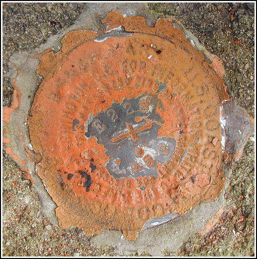
E 228 (LY1533)
E 228
Spatial/elevation data
| Coordinates | N 41.106516° W 75.845233° |
| Elevation | 1249.50 ft. |
| Location | Pennsylvania
Luzerne County White Haven Quad |
Mark description
| Type | Bench Mark Disk |
| Setting | Bridge Abutment |
| Monumented | 1959 by NGS |
| Description (NGS) | NGS Datasheet |
NGS recovery information
Descriptive text
The mark is 0.4 miles west along County Road 41 from the intersection of the county road and PA Route 437.Narrative and photographs
This benchmark disk was found as described set in the southeast corner of the east abutment of the concrete bridge that carries County Road 41/Honey Hole Road over Conety Run. Blacktop Road 40040 is now PA Route 437. The disk has been covered by the same orange paint that coats the pipe railing of the bridge, but the stamping is exposed and legible and the disk is in good condition.


Recovered in good condition.
This second order vertical control station is located on the top surface of a concrete base for a steel pipe railing near the easternmost end of the south abutment of a concrete bridge over Conety Run, approximately 0.4 miles west along County Road 41 from the intersection of PA Rt. 437. The historical description leads reliably to the station. At the station a Garmin GPSmap76 receiver with remote active antenna was used to record autonomous (non-corrected) coordinates which were 159 feet from the scaled coordinates listed on the NGS datasheet. The disk is in good condition but has been painted over. The stamped designation is partially exposed and legible. ~Rich in NEPA~


