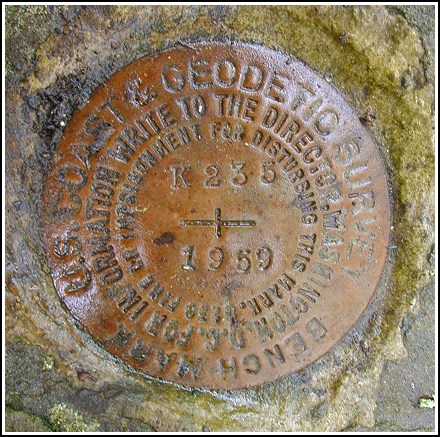
K 235 (LY1229)
K 235
Spatial/elevation data
| Coordinates | N 41.40255° W 75.14235° |
| Elevation | 1478.71 ft. |
| Location | Pennsylvania
Pike County Hawley Quad |
Mark description
| Type | Bench Mark Disk |
| Setting | Boulder |
| Monumented | 1959 by NGS |
| Description (NGS) | NGS Datasheet |
Narrative and photographs
After having trouble at nearby LY1228, Rich and I weren’t feeling too optimistic about finding benchmarks on random boulders (however large they were supposed to be!) in the woods. Fortunately, this was an easy find. The description was adequate to find the mark; once in the area we walked right up to it. The mark is in excellent condition and does not appear to have been disturbed in any way.

N 41° 24.153’ W 075° 08.541’
This vertical control station is located on the top surface of a large outcropping boulder along the east side of Rt. 402. The historical description leads reliably to the station, the mark is well exposed and was easy to find. At the station mark a Garmin GPSmap76 receiver indicated 111 feet from the scaled NGS datasheet coordinates. The disk is in very good condition and the stamped designation is legible. ~Rich in NEPA~


