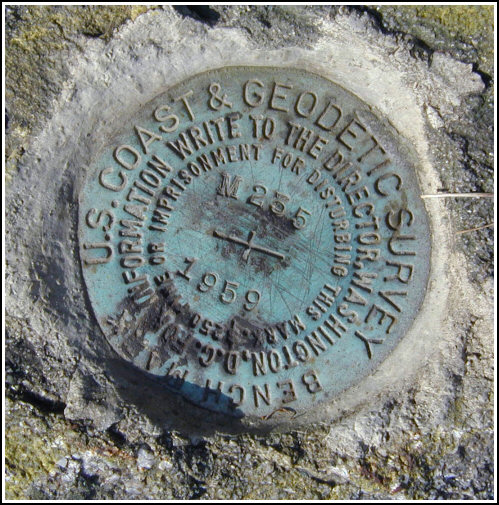
M 235 (LY1227)
M 235
Spatial/elevation data
| Coordinates | N 41.37735° W 75.1304° |
| Elevation | 1429.25 ft. |
| Location | Pennsylvania
Pike County Hawley Quad |
Mark description
| Type | Bench Mark Disk |
| Setting | Boulder |
| Monumented | 1959 by NGS |
| Description (NGS) | NGS Datasheet |
NGS recovery information
Descriptive text
Recovered in good condition. The mark is 16, not 6, feet west of the centerline of the highway. It is located approximately 60 feet southwest and across the highway from powerpole 2T17875 6(1/2) ATTCH 71877/N45218, and 10 feet north of a highway speed limit sign.Narrative and photographs
On this chilly Sunday, Rich and I decided to continue our search for marks in the 235 series in Pike County. This was our first stop. Though the historic description of this mark contained some inaccuracies, the mark was still easy to find. It is marked by an old ring of yellow paint. The disk is in good condition with just a few shallow scratches on its surface. All stamping is legible.


Recovered in good condition.
This second order vertical control station is set in the top of an outcropping boulder along the south-bound shoulder of PA Rt. 402. The historical description leads reliably to the station, except that it is 16 feet west of the centerline of the highway. In addition, it is 10 feet north of a highway speed limit sign, and roughly 60 feet southwest of powerpole #2T17874 6½ ATTCH 71877/N45218. At the station a Garmin GPSmap76 receiver with remote active antenna was used to record WAAS-corrected coordinates which were 94 feet from the scaled coordinates listed in the NGS datasheet. The mark is well exposed, in good condition, and the stamped designation is legible. ~Rich in NEPA~


