PTS 22 (LY1238)
PTS 22
Spatial/elevation data
| Coordinates | N 41.46335° W 75.12365° |
| Elevation | 848.71 ft. |
| Location | Pennsylvania
Pike County Rowland Quad |
Mark description
| Type | Bench Mark Disk |
| Setting | Rock Outcrop |
| Monumented | 1919 by USGS |
| Description (NGS) | NGS Datasheet |
NGS recovery information
Descriptive text
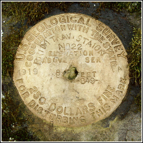
Recovered in good condition. The mark is set vertically in the northeast face of a rock ledge along the tracks of the Lackawanna and Stourbridge Railroad, approximately 0.2 miles SE of the Decker Hollow Road (T458) crossing. The railroad station no longer exists and no evidence of it was found. There is a 3/16-inch x 3/8-inch hole through the center of the disk that obscures one corner of the triangle, but does not appear to have disturbed the remainder of the disk or the setting. The stamping is legible.Narrative and photographs
This was to be the final mark for the day, after locating LY1235 nearby. Continuing along T495, a narrow lane skirting the ridge above the tracks and the Lackawaxen River, we looked for a good place to climb down toward this mark. The presence of rocky cliffs all along the distance we traveled was not encouraging, so we backtracked and parked in an empty lot just beyond the bridge over the railroad tracks, and walked southeast along the tracks toward the mark. It was easy to spot the bright yellow disk from a distance. It’s set vertically into a ledge just south of the Lackawaxen and Stourbridge Railroad tracks. The disk has a few unusual characteristics. There’s a small hole through the center, though the disk doesn’t appear to have been disturbed or otherwise damaged. In addition, the stamping appears to have been done with only a set of number stamps. Close inspection reveals that the letters stamped on the disk are actually constructed from the number “1” (and “0” where appropriate). It appears to have taken a bit of work to stamp the letters (and apparently they accidentally omitted the second “T” in STATION). I have to wonder just what happened on that day in 1919.


N 41° 27.796’ W 075° 07.419’
Recovered in good condition.
This second order vertical control station is set in the northeast face of a high outcropping ledge along side the tracks of the Lackawaxen & Stourbridge Railroad, roughly 0.2 miles southeast of the Decker Hollow Road (T458) crossing. The historical description leads reliably to the station mark, except that the railroad station no longer exists. At the station mark a Garmin GPSmap76 receiver with remote active antenna was used to record autonomous (non-corrected) coordinates which were 79.6 feet from the scaled coordinates listed in the NGS datasheet. The mark is well exposed, in fair condition (there’s a small hole through the center), and the stamped designation is readable upon close inspection. ~Rich in NEPA~


