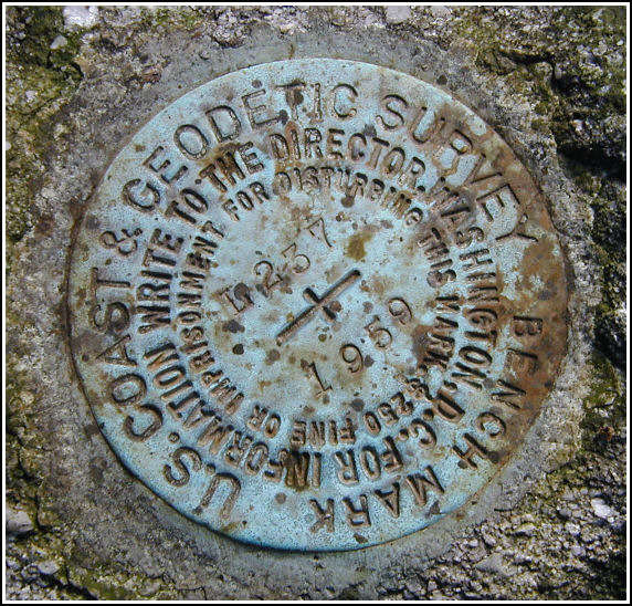
L 237 (LY1160)
L 237
Spatial/elevation data
| Coordinates | N 41.321566° W 75.17325° |
| Elevation | 1877.16 ft. |
| Location | Pennsylvania
Pike County Promised Land Quad |
Mark description
| Type | Bench Mark Disk |
| Setting | Boulder |
| Monumented | 1959 by NGS |
| Description (NGS) | NGS Datasheet |
NGS recovery information
Descriptive text
Station mark recovered in good condition. The mark is set in the top of an outcropping boulder at the intersection of Telephone Trail and Bruce Lake Trail, at trail marker 76. It is 23 feet (7 meters) southwest of Telephone Trail, 17 feet (5.2 meters) northwest of Bruce Lake Trail, and 40 feet (12.2 meters) southwest of a tree with sign ‘Bruce Lake Trail’. Autonomous (non-corrected) handheld GPS coordinates for the station are 41 19 17.82(N) 075 10 23.94(W).Narrative and photographs
After a successful recovery (on our second try) of LY1161, we hiked further along the Telephone Trail to this mark, the next in the series. The historic description brought us directly to the mark, which we found without difficulty on an outcropping boulder at the intersection of Telephone and Bruce Lake trails. The disk is in good condition with legible stamping. We took measurements from nearby reference objects for inclusion in our official recovery, and then we continued our hike eastward to the outer reaches of Promised Land State Park in order to recover the next mark in the series, LY1159—or at least that was the plan.


.")
Station recovered in good condition.
This second order vertical control station is set in the top of an outcropping boulder at the intersection of Telephone and Bruce Lake trails within Promised Land State Park, at trail marker #76. The historical description leads reliably to the station. Station is 23 feet southwest of Telephone Trail, 17 feet northwest of Bruce Lake Trail, 40 feet southwest of the Bruce Lake sign on a tree near the trail intersection. At the station a Garmin GPSmap76 receiver with remote active antenna was used to record autonomous (non-corrected) coordinates which were 352 feet from the scaled coordinates listed in the NGS datasheet. The mark is well exposed, in good condition, and the stamped designation is legible. ~Rich in NEPA~


