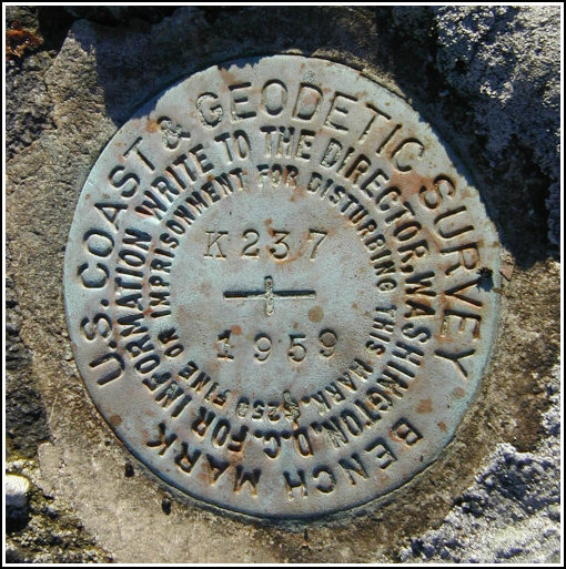
K 237
Spatial/elevation data
| Coordinates | N 41.32045° W 75.16145° |
| Elevation | 1800.73 ft. |
| Location | Pennsylvania
Pike County Promised Land Quad |
Mark description
| Type | Bench Mark Disk |
| Setting | Boulder |
| Monumented | 1959 by NGS |
| Description (NGS) | NGS Datasheet |
Narrative and photographs
Our hike along the Telephone Trail this morning has so far led to the successful recovery of two marks in the 237 series, M 237 (which actually took us two attempts) and L 237. Although the USGS topo map shows a continuation of the Telephone Trail eastward from L 237 toward K 237, and the NGS datasheet description indicates the same, we weren’t able to find any sign of the trail continuing much farther east past the site of L 237, where the Telephone Trail intersects with the Bruce Lake Trail. (Newer maps also show the Telephone Trail terminating at this point, so it has probably grown in and become completely obscured over the decades without use or maintenance.)
Still determined to reach the location and search for K 237, we decided to backtrack along the Telephone Trail and drive around to Route 402, from which we could come in from the east along Lake Laura Road. We hiked west along a trail beginning at N41° 19.234’ W075° 09.147’. A hike of just under a half mile brought us to the boundary between Promised Land State Park and the Blooming Grove Hunting and Fishing Club, where we found the boulder and the mark easily. The disk is in good condition with legible stamping.


N 41° 19.226’ W 075° 09.688’
Station recovered in good condition.
This second order vertical control station is set in the top of a large outcropping boulder at the boundary of Promised Land State Park and the Blooming Grove Hunting and Fishing Club. The historical description leads only partially to the station, and errs when it refers to a State Game Lands boundary. There is no observable trail within the State Park leading from either the Telephone trail or Bruce Lake trail. However, the station can be accessed from PA Rt. 402 via Lake Laura Road and then following a trail branching to the west at N41° 19.234’ W075° 09.147’ leading the boundary. At the station a Garmin GPSmap76 receiver with remote active antenna was used to record WAAS-corrected coordinates which were 55 feet from the scaled coordinates listed in the NGS datasheet. The mark is well exposed, in good condition, and the stamped designation is legible. ~Rich in NEPA~


