Y 59
Spatial/elevation data
| Coordinates | N 41.587433° W 75.411831° |
| Elevation | 1417.56 ft. |
| Location | Pennsylvania
Wayne County Waymart Quad |
Mark description
| Type | Bench Mark Disk |
| Setting | Concrete Culvert |
| Monumented | 1934 by NGS |
| Description (NGS) | NGS Datasheet |
Narrative and photographs
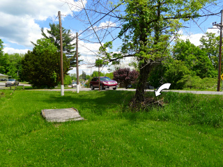
Ahh … you know it’s summer when we’re back in Waymart looking for benchmarks, and stopping for burgers at the Waymart Hotel BBQ pit. This mark was on our way to the hotel, and for some reason we had never searched for it.
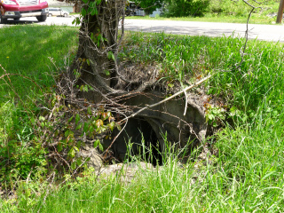
We found the right area quickly and spotted the culvert. Unfortunately, while the bench mark is very likely still there in the top of the culvert, I doubt that we’ll be able to get a look at it anytime soon. The top of the culvert is caked with dried mud several inches deep, wrapped in thick tree roots, and topped off with a copious draping of poison ivy. I’m not going anywhere near this one without some heavy equipment (and protection)! Perhaps after a good rain, closer to winter, we might be able to clear off enough of the debris to see and recover the mark.
We’re not going to report anything to NGS at this time. We would love to be able to contribute a recovery of some kind, because this mark has never been recovered since it was set in 1934. But we simply don’t have enough information at this time.


