RV 2448 (LY0800)
RV 2448
Spatial/elevation data
| Coordinates | N 41.178483° W 74.7937° |
| Elevation | 904.99 ft. |
| Location | New Jersey
Sussex County Culvers Gap Quad |
Mark description
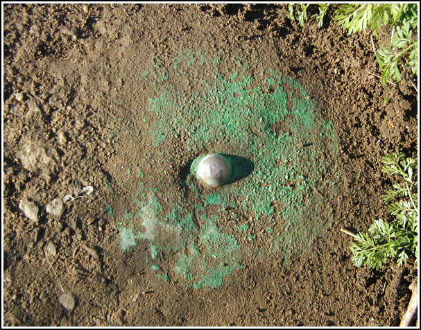
| Type | Rivet |
| Setting | Concrete bridge headwall |
| Monumented | Unknown by New Jersey Geological Survey |
| Description (NGS) | NGS Datasheet |
NGS recovery information
Descriptive text
Mark recovered in good condition. State Highway No. S 31 is now US Route 206.Narrative and photographs
“This was the most fiercely guarded benchmark I’ve yet encountered. I never imagined searching for a little rivet on a bridge in a public right-of-way would have caused us any trouble! The bridge was easily accessible, we determined as we drove by on Route 206. We parked nearby and walked to the bridge to scout it out. We could see green paint on the southeast corner of the headwall, but the area needed to be cleared before we could take photographs. Aaron remained near the bridge while Rich and I returned to the vehicle to retrieve our tools. And this is where things got ugly. As we walked back to the bridge, I saw and heard a confrontation taking place between Aaron and a visibly angry little man.
When we arrived, the man was gesturing wildly and screaming that we’d better “get your [expletive] off my [expletive] bridge,” “don’t even think about stealing my [expletive] water,” etc. He seemed convinced that we were “city folk,” against whom he apparently holds a grudge.
“Oh, so you say you’re not from the City. Where you from, then? Oh, I bet I know. South Jersey. Or Central Jersey!!! [Expletive] city folk!”
“We’re Americans! That’s all you need to know.”
“Well, then that’s one thing you got going for you. I been overrun with these [expletive] Hindus and blacks!”
Nothing we said would calm him, even when we asked “Do you own this bridge?” and he responded “No!” The cursing continued as Rich defied him and stepped over the guardrail.
“You get back on this side of that [expletive] guardrail right now!” he demanded. Rich ignored him.
“I’ll call the cops!” the man shouted.
“Go ahead.”
“I’m gonna push you right in the [expletive] water!”
“Go ahead!”
I looked on, astonished and feeling within seconds of tossing this guy over the guardrail myself. At long last, the man started to lose steam and while he was still acting guarded and macho, he did eventually listen to our explanation of the purpose of the mark and read the datasheet while we photographed the mark. For the time being, we decided to forget about the mark on the opposite headwall of the bridge and just get out while the getting out was good. The man’s last grumble to us was something like “well, at least you’re not [expletive] Hindus.”


N 41° 10.709’ W 074° 47.623’
Recovered in good condition.
This second order vertical control station is set in the top of the southwest headwall of a concrete bridge along U.S. Rt. 206 (formerly State Highway S31) crossing a small stream feeding Kittatinny Lake. The historical description leads reliably to the station. The station mark is a standard monel rivet and appears to be in good condition. At the station a Garmin GPSmap76 receiver with remote active antenna was used to record WAAS-corrected coordinates which were 116 feet from the scaled coordinates listed on the NGS datasheet. ~Rich in NEPA~


