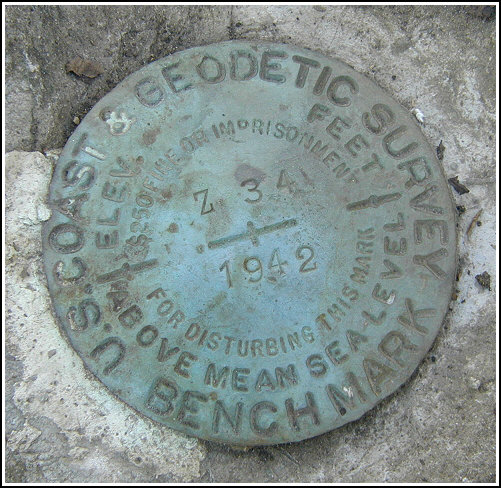
Z 34 (LY0786)
Z 34
Spatial/elevation data
| Coordinates | N 41.229733° W 74.84225° |
| Elevation | 682.42 ft. |
| Location | New Jersey
Sussex County Culvers Gap Quad |
Mark description
| Type | Bench Mark Disk |
| Setting | Rock Outcrop |
| Monumented | 1942 by NGS |
| Description (NGS) | NGS Datasheet |
NGS recovery information
Descriptive text
Recovered in good condition. The blacktop road is now Sussex County Road 1. The gravel road is now paved and is named Upper Ridge Road. The fences no longer exist. The station is 40 feet west of U.T. Co. of New Jersey pole number 118.Narrative and photographs
Following our encounter with New Jersey’s loudest madman (at LY0800), we thought a search for a mark in a more isolated area was in order. This mark, located just WNW of the intersection of Sussex County Road 560 and Upper Ridge Road, became our goal. The mark was simple to locate based on the historic description, although several details have now changed. Because the fences no longer exist, we recorded a measurement from the nearest powerpole to the station mark. The disk is in good condition and the date and designation are legible.


N 41° 13.786’ W 074° 50.535’
Recovered in good condition.
This second order vertical control station is set in top center of an outcropping boulder nearly flush with the ground in a brush-covered depression roughly 25 yards west-northwest of the intersection of county road #560 (the blacktop road) and Upper Ridge Road (the gravel road, now paved). The historical description leads reliably to the station. The northwest-southeast fence and the northwest right-of-way fence no longer exist. The station is 40 feet west of U.T. Co. of N.J. powerpole number 118. At the station a Garmin GPSmap76 receiver with remote active antenna was used to record autonomous (non-corrected) coordinates which were 311.5 feet from the scaled coordinates listed on the NGS datasheet. The station mark is in good condition, and the stamped designation is clearly legible. ~Rich in NEPA~


