437 (LY0512)
437
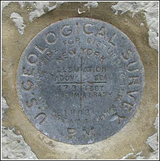
Spatial/elevation data
| Coordinates | N 41.2762° W 74.41145° |
| Elevation | 472.48 ft. |
| Location | New York
Orange County Pine Island Quad |
Mark description
| Type | Bench Mark Disk |
| Setting | Stone Building |
| Monumented | 1903 by USGS |
| Description (NGS) | NGS Datasheet |
NGS recovery information
Descriptive text
Recovered in good condition. The mark is set vertically in the southeast face of the Dr. James Young house at 260 Pine Island Turnpike.Narrative and photographs
I made this mark a priority for the day, initially intrigued by the fact that it was said to be set in the wall of an old stone house. I expected the mark to be on private property and was ready to drive on by if the home appeared to be inhabited, but my father and I were in for a treat. Not only is the house an absolutely beautiful early 19th century native stone block structure, but we found and documented the mark and also met the owner and restorer of the house!
The house is surrounded by a low picket fence, and as we approached we immediately spotted the mark just to the right of the front door. We let ourselves in through the gate, but knocked on the door to ask permission before taking photos of the mark or the house. After a few minutes a sleepy-looking man answered the door and stated that he had no problem whatsoever with us documenting the mark. As I worked, my father talked with the man. We discovered that he and his partner have owned the house since 1985 and have made it their project to restore the house to its original condition (allowing for, I’m assuming, a few modern conveniences here and there). They also have a carriage house and prize-winning gardens in the back.
In addition, it is interesting to note that Dr. James P. Young, for whom the house was built in 1816, was an avid geologist. He was involved in several projects involving geologic mapping of the surrounding areas. I’m sure he would have been honored that his house was chosen for the site of a U.S.G.S. benchmark.


