HIGH TOR RESET (LX4218)
HIGH TOR RESET
Spatial/elevation data
| Coordinates | N 41.187616° W 73.96535° |
| Elevation | 823 ft. |
| Location | New York
Rockland County Haverstraw Quad |
Mark description
| Type | Triangulation Station Disk |
| Setting | Bedrock |
| Monumented | 1851 by NGS |
| Description (NGS) | NGS Datasheet |
NGS recovery information
Descriptive text
Recovered in destroyed condition.Narrative and photographs
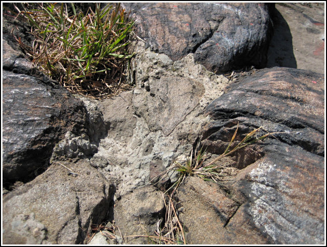
Like LX4216 just a meter away, this station has a long and fascinating history. Similar to most of these old tri-stations, it began as a simple drill hole in bedrock, decades later marked by a disk and surrounded by reference marks. The disk no longer exists, but plenty of evidence still at the site (as well as our GPS coordinates) have us almost certain we have identified the point at which it was set.
Perhaps most historically interesting are the sets of drill holes found nearby. Although the datasheet is not entirely clear, it appears as though there were two sets of four drill holes surrounding the station, an inner and an outer set, and that the station hole was located at the intersection of the lines between the inner drill holes. Drill holes were evident all over the bedrock atop High Tor, and though we cannot be certain, we were able to identify likely candidates for the inner and outer sets referred to in the description. Reference mark 1 was set into one of the inner drill holes, while reference mark 2 was set into one of the outer holes, according to the datasheet. This made us more confident of our identification.
The point where we think the station was located is also at the correct distance and direction from both reference marks (whose locations we were able to identify, though neither disk still exists), the steel & concrete footings from the beacon tower, and the mysterious squared-off bolt which we think is the broken remains of the map control disk referred to in LX4216. As an additional set of measurements, we found the station point to be approximately 11 feet south of the NE footing, 11 feet 10 inches SSE of the NW footing, and 12 inches SSE of a line between the centers of the SW and SE footings.
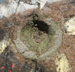
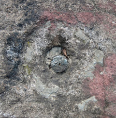
Reference mark 1 is entirely missing, though its impression and some cement are still visible in the bedrock. The shank remains of reference mark 2. We believe that we have found the correct location and have shown this station to be destroyed, but will allow NGS to make the final determination.
Beautiful views over the Hudson, Haverstraw and Haverstraw Bay abound up here, as do sunshine and dry breezes. It was a perfect spot to spend a few hours deciphering datasheets and searching around for clues to the real story behind these tri-stations!


| Designation | Status | Condition | Image |
|---|---|---|---|
| HIGH TOR RESET RM 1 | Recovered | Destroyed |
|
| HIGH TOR RESET RM 2 | Recovered | Poor |
|