H 362 (KV2873)
H 362
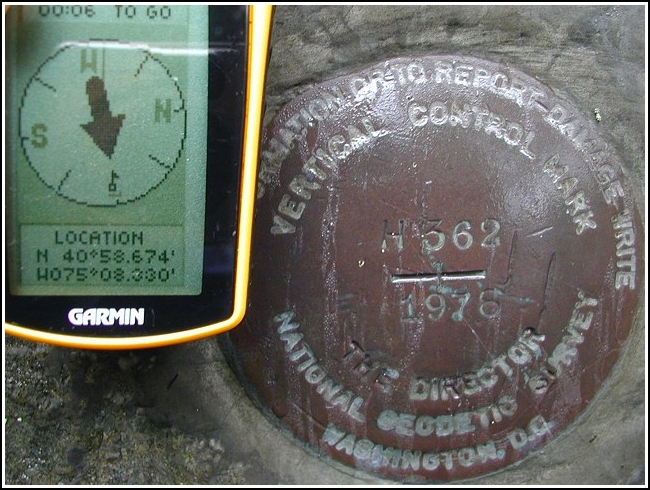
Spatial/elevation data
| Coordinates | N 40.9779° W 75.138833° |
| Elevation | 401.11 ft. |
| Location | Pennsylvania
Monroe County Stroudsburg Quad |
Mark description
| Type | Vertical Control Mark |
| Setting | Rock Outcrop |
| Monumented | 1978 by NGS |
| Description (NGS) | NGS Datasheet |
NGS recovery information
Descriptive text
Recovered in good condition. Handheld GPS coordinates are 40 58 40.4(N) 075 08 19.8(W).Narrative and photographs
Found it this warm, rainy day after picking up our Status Crow reward cache across the river. We parked in the Resort Point Overlook lot and I crossed Route 611 to look for the marker. The coordinates were a few hundred feet off, and the sign mentioned in the description is no longer there (a similar sign exists, but it’s apparently been moved a few feet up the road). Still, the marker was quite easy to find. As I was stepping over weeds and brambles by the side of the highway, some self-appointed constable drove up and was eyeing every car in the parking lot (I found out later). He questioned Aaron about what I was doing across the street! This marker is in a very exposed location very close to the road—it can even be seen when you drive by if you know where to look. I had to get a little closer to take the photo, but it wasn’t as if I was scaling the hillside. I wasn’t aware it required a permit to walk along the side of the road! Some people need to mind their own business. When I crossed back to the lot, he was still there but didn’t say anything to me. I ignored him, took a few photos, and we left—one benchmark richer, completely soaked, and with a semi-interesting story to tell!


 from Resort Point Overlook")
