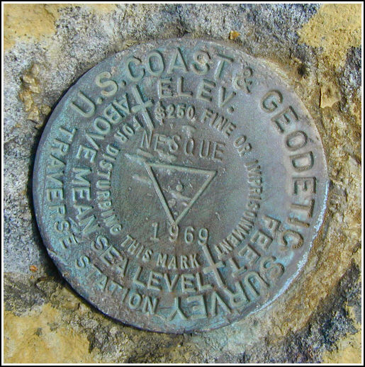
NESQUE (KV3863)
NESQUE
Spatial/elevation data
| Coordinates | N 40.879066° W 75.797683° |
| Elevation | 1405 ft. |
| Location | Pennsylvania
Carbon County Weatherly Quad |
Mark description
| Type | Triangulation Station Disk |
| Setting | Rock Outcrop |
| Monumented | 1969 by NGS |
| Description (NGS) | NGS Datasheet |
NGS recovery information
Descriptive text
The station mark, reference marks 1 and 2, and the azimuth mark were recovered in good condition. Very little remains of old Route 93. The large white boulder has been painted yellow-orange and is visible from the base of the butte. The witness post was not found, and the six-inch maple tree is now a group of three maples surrounded by rocks at their base.Narrative and photographs
While in Jim Thorpe for a day of mountain biking with friends, Rich and I took a few hours to ourselves in the morning to recover some local benchmarks. We parked in a small gravel lot just off the road to the Carbon County Correctional Facility and adjacent to Route 93. We then walked northward along Route 93 less than 1/4 mile to the point where old Route 93 once intersected from the west, as was evident from little more than a high berm along the shoulder, some asphalt pieces, and an open area beyond.
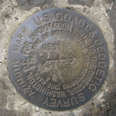
With the beautiful view of the town of Nesquehoning as our background scenery, we searched the clearing for the azimuth mark. The chunks of asphalt that remained were of little help in determining the original route or size of old Route 93, so it was impossible to take any measurements from the road. No witness post was found at this site, so we had very little to go on. After a lengthy search, the mark was found in good condition atop a small outcropping boulder. We determined the location of the six-inch maple tree and were surprised to find that it is now a group of three trees, and the trunk of the largest bears red painted marks which appear to be surveyors’ notations.
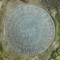
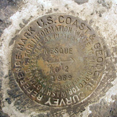
We followed the slight remnants of Old Route 93, still distinguishable but little more than a path, northwest toward the station. The white boulder mentioned in the description has now been painted a brilliant yellow-orange. We viewed it from the base of the rock pile and hiked the steep, slippery slope toward it. Fifteen feet from the boulder’s base, ringed in yellow paint, we spotted the station mark set in outcropping bedrock. After a short search, the two reference marks were found in good condition as described.


This second order horizontal triangulation station is located on a high butte formed from an immense rock pile between Route 93 and the remains of old Route 93, roughly ½ mile northbound along Route 93 from the entrance to the Carbon County Correctional Facility. The 1969 historical description leads reliably and easily to the station and all reference marks. It was possible to park in a gravel pull-off at the start of the prison entrance road, hike upward along the wide shoulder of Route 93 to the north end of the southbound guardrail and to a berm where old Route 93 once intersected. On the other side of the berm is a large grassy clearing overlooking the town of Nesquehoning. Sections of old macadam can be seen leading in a west-northwesterly direction and mostly parallel to Route 93. The azimuth mark is on the top of a small outcropping boulder near a cluster of scrubby pine trees. The 6-inch maple tree is now a group of three maples surrounded by rocks at the base of their trunks. There are red painted markings on the side of the largest tree trunk at eyelevel. The metal witness post no longer exists.
The station is roughly 1/3 mile further along the path following the remnants of old Route 93. The large white boulder is now painted bright yellow-orange and can be seen from the base of the rock pile butte. The top of the butte is reached by following along the south side of the base of the rock pile (counterclockwise) up to the east side of the rock pile nearest to and above the highway, then scrambling up the rocks a short distance. At the station a Garmin GPSmap76 receiver with active remote antenna was used to record WAAS-corrected coordinates which were zero feet from the adjusted coordinates listed on the NGS datasheet. RM2 is set close to the level of the ground and was obscured by a layer of duff. All marks including the azimuth are well exposed, in excellent condition, and the stamped designations are clearly legible. ~Rich in NEPA~


| Designation | Status | Condition | Image |
|---|---|---|---|
| NESQUE AZ MK | Recovered | Good |
|
| NESQUE RM 1 | Recovered | Good |
|
| NESQUE RM 2 | Recovered | Good |
|