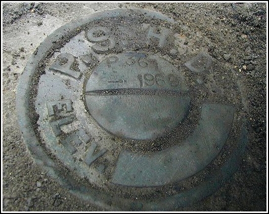
P 361 PADH (KV2795)
P 361 PADH
Spatial/elevation data
| Coordinates | N 40.849917° W 75.613383° |
| Elevation | 864.29 ft. |
| Location | Pennsylvania
Carbon County Palmerton Quad |
Mark description
| Type | Elevation Mark |
| Setting | Bridge Wingwall |
| Monumented | 1969 by PA Dept. of Highways |
| Description (NGS) | NGS Datasheet |
NGS recovery information
Descriptive text
Recovered in good condition as described. Handheld GPS coordinates for the bench mark are 40 50 59.6(N) 075 36 48.2(W).Narrative and photographs
Found this one this afternoon after locating two geocaches in the area. I was pretty sure which bridge I was looking for, but there wasn’t a great spot to park, and I had to drive around for a while. Finally I found a suitable parking area up the road a bit, and I ran down to the bridge. Well, this one wasn’t so easy! I knew where to look, but that area was covered with a whole lot of gravel and dirt. This was a very tricky spot in which to balance, and with the traffic whizzing by overhead it was somewhat unnerving. Still, I felt comfortable enough to take the time to dig out the mark—it was under about an inch of gravel and, I discovered as I dug away at it, something black and greasy and filthy. Coordinates were not perfect, but with the excellent description they weren’t really needed. I managed to take a few photos before sliding down the hill!
